CREATION OF THE UNIVERSE ACCORDING GENESIS |
CHAPTER X.OFFICIALEXPLORATIONS. 1773-1779.
The gradual establishment of Russian
supremacy in north-westernmost America upon a permanent basis had not escaped
the attention of Spanish statesmen. Within a few years after the disastrous
failure of the Russian exploring expeditions under Krenitzin and Levashef, a succinct account of all that had been
accomplished by the joint efforts of the promyshleniki and the naval officers, under the auspices of the imperial government, bad been
transmitted to the court of Spain by its accredited and secret agents at St
Petersburg.
Alarmed
by tidings of numerous and important discoveries along the extension of her own
South Sea coast line, Spain ordered an expedition for exploring and seizing the
coast to the northward of California. In 1773 accordingly the viceroy of
Mexico, Revilla Gigedo, assigned for this purpose the new transport Santiago,
commanded by Juan Perez, who was asked to prepare a plan of operations. In this
he expressed his intention to reach the Northwest Coast in latitude 45° or 50°;
but his orders to attain a higher latitude were peremptory, and it is solely
owing to this that the voyage falls within the scope of the present volume.
Minute directions were furnished for the ceremonies of claiming and taking
possession. The wording of the written declaration, to be deposited in
convenient and prominent places, was prescribed. The commander was instructed
to keep the object of his voyage secret, but to strike the coast well to north,
in latitude 60° if possible, and to take possession above any settlements he
might find, without, however, disturbing the Russians. Appended to his
instructions was a full translation of Staehlin’s Account of the New
Northern Archipelago, together with the fanciful map accompanying that
volume. Each island of the Aleutian group was described in detail, besides many others, the product of the fertile imagination of such men as
Staehlin and De L’Isle de la Croyère.
Even the island of Kadiak, which had then only been twice visited by promyshleniki, was included in the list.
The Santiago sailed from San Blas January 24, 1774, with eighty-eight men,
including two missionaries and a surgeon. The incidents of nearly the whole of
this voyage occurred south of the territory embraced by this volume; but
between the 15th and 17th of July Perez and his companions sighted two capes,
the southernmost of which he thought was in latitude 55°, and the other about
eight leagues to the north. These points were named Santa Margarita and Santa
Magdalena, respectively.
These
capes, the southernmost point of Prince of Wales Island, and the north point of
Queen Charlotte Island, lie on both sides of the present boundary of Alaska,
but Perez and his men had intercourse with the inhabitants of the latter cape
only. The mere sighting of one of the southern capes of Alaska, and its
location by rough estimate, would scarcely justify a discussion of the voyage
of Juan Perez in the annals of Alaska, were it not for an apparently trifling
incident mentioned in the various diarios of
this expedition. In the hands of the natives were seen an old bayonet and
pieces of other iron implements, which the pilot conjectured must have
belonged to the boats’ crews lost from Chirikof’s vessel somewhere in these latitudes in 1741. In the absence of all
knowledge of any civilized visitor to that section during the interval between Chirikof’s and Perez’ voyages we cannot well criticise the conclusion arrived at. It could scarcely be
presumed that at that early date a Russian bayonet should have passed from
hand to hand or from tribe to tribe, around the coast from the Aleutian
Islands, or perhaps Kadiak, a distance of from eight hundred to one thousand
miles. It appears highly probable that Chirikof’s mishap occurred in this vicinity, the Prince of Wales or Queen Charlotte
Islands, and in that case the present boundary of Alaska would be very nearly
identical with the northern limit of the territorial claims of Spain as based
upon the right of discovery. The avowed objects of this voyage had not been
obtained by Perez; he did not ascend to the latitude of 60°; he did not
ascertain the existence of permanent. Russian establishments, and he made no
discoveries of available sea-ports. His intercourse with the Alaskan natives,
if such they were, was carried on without anchoring. The details of the
expedition of Perez, so far as they relate to incidents that occurred south of
the line of 54° 40', are discussed in my History of the Northwest Coast.
The
second Spanish expedition which extended its operations to Alaskan waters was
organized in the following year, 1775. The command was intrusted to Bruno Heceta, a lieutenant and acting captain, who
selected the Santiago as his flag-ship. Juan Perez sailed with Heceta as pilot and second in command. The small schooner Sonora,
or Felicidad, accompanied the larger craft as consort, commanded by
Lieutenant Juan Francisco de Bodega y Cuadra, with Antonio Maurelle as pilot.
The
expedition sailed from San Blas March 16th. After going far out to sea and
returning to the coast again in latitude 48° on the 14th of July, taking possession
of the country, and after a disastrous encounter with the savages of that
region, the two vessels became separated during a northerly gale on the 30th
of July.
The Sonora alone made discoveries within the present boundaries of Alaska. After
the separation the little craft, only 36 feet in length, was boldly headed
seaward and kept upon a general north-westerly course. On the 13th of August
indications of land were observed, though the only chart in their possession,
that of Bellin, based upon Russian discoveries and to a great extent upon
imagination, placed them at a distance of one hundred and sixty leagues from
the continental coast. Cuadra’s latitude, by observation, on that day was 55°
40'. During the next two days the signs of land became stronger and more
frequent, and the navigators, in the belief that they were approaching the Tumannoi or Foggy Islands of Chirikof, observed the
greatest caution.
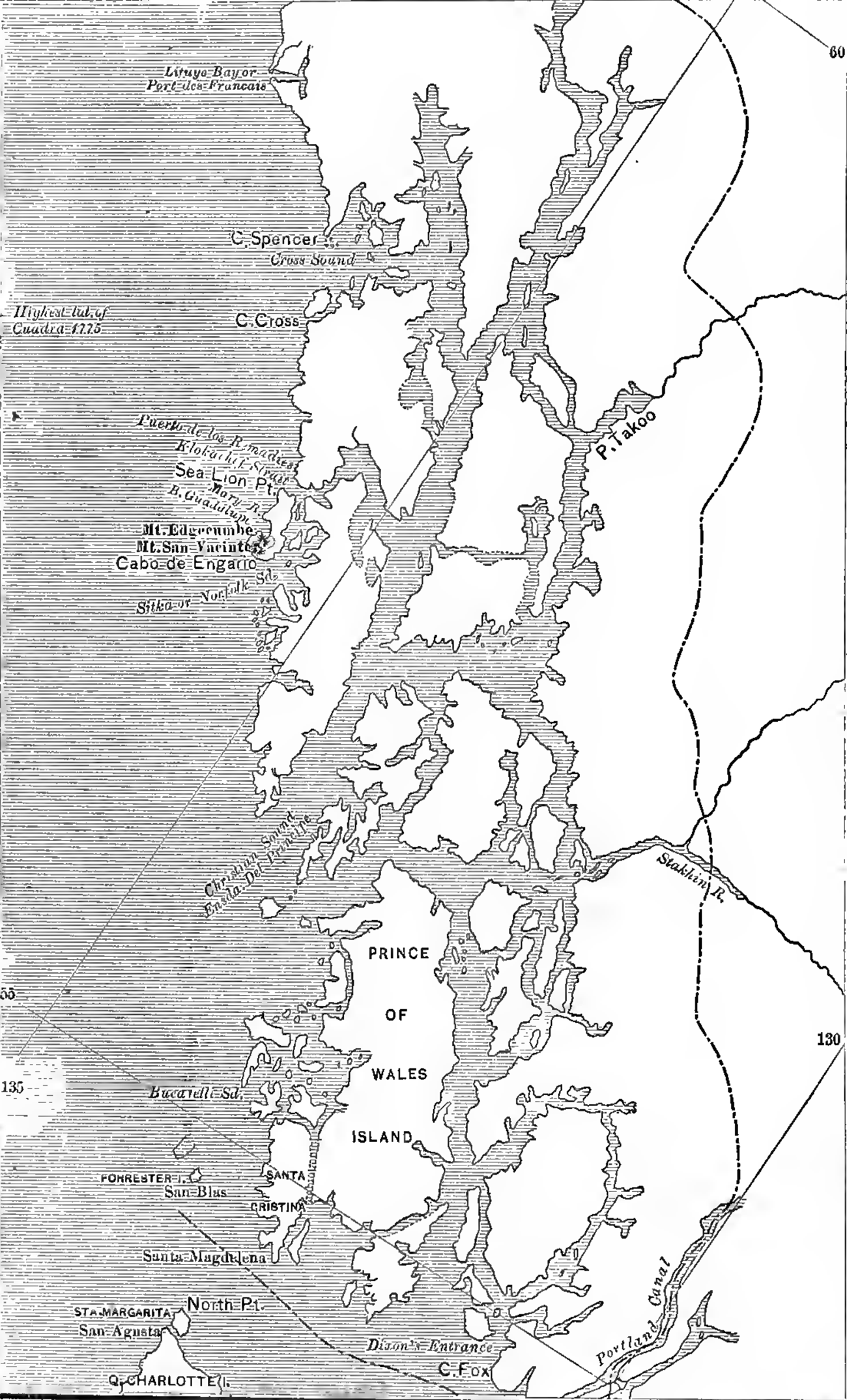
At
last, on the 16th, came in view a mountainous coast among whose many peaks was
one they called San Jacinto, and the prominent cape jutting from it the Cabo de Engaño. Their description of both cape and mountain
is so clear as to leave no doubt of their identity with the Mount Edgecumbe of
Cook and the cape of the same name. That the original nomenclature has not
been preserved is owing to Spain’s neglect in not publishing the achievements
of her explorers.
On
the following day the goleta put to sea again,
weathering Cape Engano and following the coast in a
north-westerly direction until another wide estuary was discovered and named
the bay of Guadalupe, subsequently known as Shelikof Bay or Port Mary. Here
Cuadra anchored for the day, observing the wooded shores rising at an acute
angle from the sea. In the morning of the 18th two canoes, containing two men
and two women, emerged from the head of the bay, but at the sight of the vessel
they hurriedly landed and fled. The explorers then put to sea again and
proceeded in a northerly direction until a good anchorage was found in
latitude 57° 20', with a good sandy beach and convenient watering-places.
A
landing was effected at the mouth of a stream, near a deserted hut and a
stockaded enclosure, probably used for defence by
the natives. The instructions of the viceroy, concerning the forms of taking
possession, were carried out so far as circumstances would permit.
During
the ceremonies no natives were in sight, but after returning to their vessel
the Spaniards saw the savages take up the cross which they had planted and
place it before their hut, as if to say “this is the better place.”
On
the 19th another landing was made, when the natives emerged from the forest waving
a white cloth attached to a pole in token of peaceful intentions. The signal
was answered by the Spaniards and the savages advanced slowly to the opposite
bank of the stream. They were unarmed and accompanied by women and children. A
few trifling presents were offered and received by one of the natives who waded
into the middle of the stream. This friendly intercourse was, however, suddenly
interrupted when the Spaniards began to fill their water-casks. The women and
children were at once sent away and the men assumed a threatening attitude.
The Spaniards prepared for defence while preserving
an unconcerned air, and finally the savages retreated.
The
place of this first landing of Spanish explorers upon Alaskan soil was called
the anchorage “de los Remedios” and can be nothing
else than the entrance to Klokachef Sound between Kruzof and Chichagof islands.
The
weather was cold and threatening during the sojourn of the Sonora in
this bay, and both officers and the poorly clothed and sheltered crew began to
suffer from scurvy. They took a west-north-westerly direction on the 21st, in
order to ascertain whether their discovery was located on the west or east
shore of the Pacific, a doubt engendered by the great difference in longitude
between the Russian discoveries as indicated on Bellin’s chart and their own;
and having by that time reached a latitude of 57° 58', or the vicinity of Cross
Sound, they changed their course to the southward to examine carefully all the
inlets of the coast.
On
the 24th of August, in latitude 55° 14', the explorers entered a magnificent
sound extending far to the northward and abounding in sheltered anchorages.
Cuadra was ill, but he ordered the piloto to
take possession in the name of Spain, and for the second time the royal banner
of Castile waved over Alaska. The sound was called Bucareli,
a name still preserved on many maps. It is located on the west coast of the
island subsequently named after the prince of Wales.
After
a careful inspection of the bay, during which not an aboriginal was to be seen,
the Sonora once more stood out to sea, sighting six leagues from the
harbor an island which was named San Blas, the same seen in 1774 by Juan Perez
from Cape Santa Margarita, and named by him Santa Cristina. It is now known as
Forrester Island. A landing was effected and water obtained, while the south
point of Prince of Wales Island, named Santa Magdalena by Perez, was plainly in
view. Contrary winds kept the little craft beating about until the navigators
succeeded in again making the coast in latitude 55° 50', where a deep
indentation was observed, with its western point in latitude 56° 3'. Thence a
high mountainous coast was seen extending north-westerly to a point marking the
southern limit of the broad estuary bounded by Cabo de Engaño in the north.
From
the 28th of August to the 1st of September the winds compelled the navigators
to hug the shore in the vicinity of latitude 56° 30’. The crew, weakened by
scurvy, were unable to combat the adverse winds. The vessel was swept by
tremendous seas; spars and portions of the rigging were carried away; and when
at last a steady strong north-wester began to blow, both commander and pilots
concluded that further efforts to gain the desired latitude were useless. The
prow of the Sonora was turned southward and the swelling sails soon carried her
far away from Alaska.
Orders
for another Spanish expedition to the north coast were issued in 1776, but
preparations were not completed till 1779, or until after Cook’s important
English explorations in this quarter.
The
voyage of Captain Cook with the ships Resolution and Discovery has been discussed at length in an earlier volume, with reference to
discoveries on the Northwest Coast south of the present boundary of Alaska. It
is only necessary here to repeat briefly a few paragraphs from Cook’s secret
instructions from the admiralty and to take up the thread of narrative where I
dropped it in the historic precincts of Nootka.
After
ordering the commander to go from New Zealand to New Albion and avoid touching
Spanish territory, the document goes on to say: “And if, in your farther
progress to the northward, as hereafter directed, you find any subjects of any
European prince or state upon any part of the coast you may think proper to
visit, you are not to disturb them, or to give them any just cause of offence,
but on the contrary to treat them with civility and friendship. Upon your
arrival on the coast of New Albion you are to put into the first convenient
port to recruit your wood and water, and procure refreshments, and then to
proceed northward along the coast, as far as the latitude of 65,° or farther,
if you are not obstructed by lands or ice; taking care not to lose any time in
exploring rivers or inlets, or upon any other account, until you get into the
before-mentioned latitude of 65°.” After being enjoined at length to make a
thorough search for a navigable passage into Hudson or Baffin bays, Cook is
further instructed as follows: “You are also, with the consent of the natives,
to take possession, in the name of the King of Great Britain, of convenient
situations in such countries as you may discover, that have not already been
discovered or visited by any other European power... but if you find the
countries so discovered are uninhabited, you are to take possession of them for
his Majesty, by setting up proper marks and inscriptions, as first discoverers
and possessors.” During the discussion of Cook’s progress in viewing the coasts
of Alaska I shall have occasion to refer to these instructions.
On
the 26th of April 1778 the expedition sailed out of Nootka Bay on its northward
course, but violent gales drove it from the land which was not made again
until the evening of May 1st in latitude 55° 20', in the vicinity of Port Bucareli, discovered by Cuadra three years before.
On
the 2d and 3d of May Cook passed along the coast included in Cuadra’s
discoveries of 1775, giving to Mount San Jacinto and the Cabo de Engano the name of Edgecumbe. Puerto de los Remedios was named bay of Islands, and Cook correctly surmised its connection
with the bay lying eastward of Cape Edgecumbe. In the morning of the 3d the two
sloops had reached the highest latitude attained by Cuadra; a high mountain in
the north and a wide inlet were called Mount Fairweather and Cross Sound respectively,
by which names both are known to this day. Cape Fairweather has
since been named Cape Spencer. On the 5th Mount St Elias was sighted above the
northern horizon, one hundred and twenty miles away, and the following day the
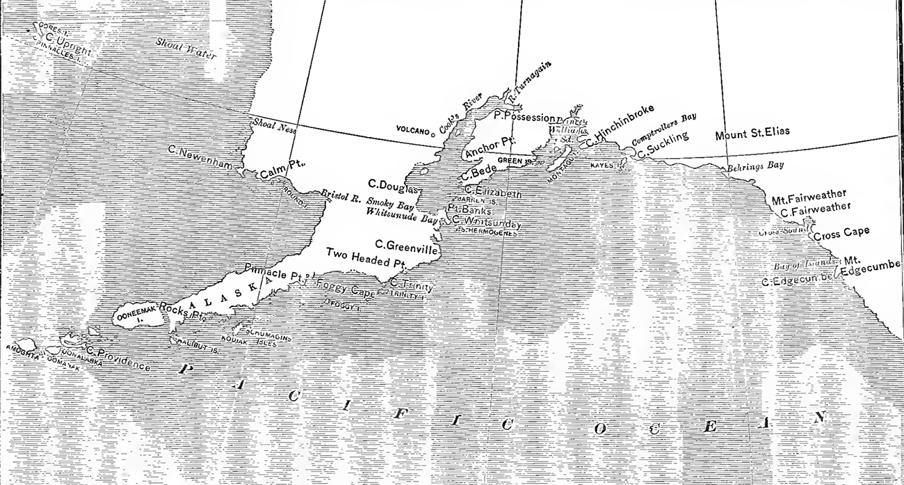
broad opening of Yakutat, or Bering, Bay was observed.
Proceeding
slowly along the coast with baffling winds, he on the 10th gave the name of
Cape Suckling to the cape forming the southern extremity of Comptroller Bay,
but owing to ‘thick’ weather Kyak Island, named Kaye
by Cook, was not discovered until two days later. At the foot of a tree on the
south point of Kaye Island a bottle was deposited containing a paper with the
names of the ships and date of ‘discovery,’ and a few coins. For some reason
the ceremony of taking possession was omitted, though Cook must have believed
in the existence of all the conditions mentioned in his instructions and
relating to ‘ uninhabited ’ discoveries.
The
name of Comptroller Bay was also applied to the indentation bearing that
designation today. The sight of the south point of Nuchek Island, named by him Cape Hinchinbrook, led Cook to indulge in hopes of finding
a passage to the north beyond it, the towering heights that border Prince
William Sound not being visible at the time. A leak in the Resolution induced the commander to seek shelter, and the ships were anchored in one of
the coves of Nuchek Bay, the Port Etches of later
maps. A boat’s crew sent out to hunt met with a number of natives in two skin
canoes, who followed them to the immediate vicinity of the ships, but would not
go on board. On the following day, the 13th, Cook sailed again in search of a
safer anchorage, without discovering the landlocked cove on the north side of
the bay subsequently selected by the Russians for their first permanent
establishment in this region. The next anchorage was found some eight leagues
to the northward at Snug Corner Cove, still known by that name. Here considerable
intercourse with the natives took place. They were bold, inclined to thievery,
and apparently unacquainted with fire-arms.
After
several vain attempts to find a northern passage the two ships turned
southward, and the largest island in the sound was discovered and named
Montagu, the Sukluk of the natives. The name of
Prince William Sound was then applied to the whole inlet.
On
the 21st Cape Elizabeth, the south-eastern point of Cook Inlet, was first
sighted and named; and as the western shore of that great estuary was not visible,
the hopes of finding an open passage to the northward were once more revived. A
gale, however, prevented the explorers from rounding the cape, and
necessitated a southerly course, which brought into view the point of land
named Cape St Hermogenes by Bering—the eastern cape of Marmot Island. Thence
the course was northward, which opened before the eyes of the explorer the
broad estuary still bearing the name of the commander. Believing that Kadiak
and Afognak islands, with Point Banks, formed but a part of the mountainous
coast to the westward, with Cape Douglas in the foreground, Cook entered the inlet
full of hope. Was not the Aliaska of Russian maps
represented as an island? And must not this wide passage lead the navigator
into the Arctic Ocean between this island and the continent? The discovery of
an extension of the high mountains to the north of Cape Douglas did not
discourage him. On the same day, however, the 27th of May, these
high hopes were crushed, as far as Cook himself was concerned. The haze hanging
over the land in the west suddenly disappeared, and what had been taken for a
chain of islands stood revealed as the summits of a mountain range, connected
everywhere and showing every characteristic of a continent
Though
fully convinced of the futility of the attempt Cook continued to beat his
vessels up the inlet. The strong ebb-tides, running at a velocity of
four or five knots, greatly retarded their progress, and as the winds were
either light or unfavorable, it became necessary to anchor the vessels every
time the tide turned against them. The muddy water and the large quantities of
floating trees led Cook to believe himself within the mouth of a large river,
and without fully ascertaining the fact, he sailed away from his new discovery
unchanged in his opinion.
The
first natives were encountered on the 30th, and a larger party, including women
and children, visited the ships the following day. The scene of this meeting
was in the vicinity of West Foreland, or the present village of Kustatan. These savages were described by Cook as
resembling the natives of Prince William Sound, speaking the same language and
using the same kind of skin-covered canoes. From this fact we must infer that
the Innuit in those days occupied more of the coast of Cook Inlet than they do
today. It is probable, however, that these people were not permanent residents,
but engaged in a hunting expedition away from their home. Blue beads and long
iron knives were found in the possession of all these peoples. We know that
these articles came from the Russians, but Cook was loath to acknowledge the
presence of another European power.
On
the first of June the boats sent out to explore returned after having entered
the Turn-again arm of the inlet and the mouth of the Kinik River, and in the afternoon Lieutenant King was despatched to take possession of the point at which the abovementioned arm branches off
to the eastward. Some lords aboriginal were present, but it is nowhere written
that King asked their permission to take possession of the country, as the
admiralty had ordered.
On
the 4th of June the latitude of the Iliamna volcano was ascertained, but the
mountain was not named. On the 5th of June the two ships emerged from the inlet
that had been entered with such flattering hopes, and proceeded southward
along the coast of the continent in search of an opening to the westward and
northward. The season was fast advancing and much remained to be done, so they
hastened forward. Shuiak Island, Afognak, and Kadiak
were placed on their chart as one continuous coast and part of the continent,
while names were given only to the prominent headlands. On the 16th Foggy
Island, the Tumanuoi of Bering, was made, and on the
19th the two ships were passing through the Shumagin group, the largest island of which Cook erroneously, put down as Kadiak on his
chart. In this vicinity the Discovery was approached by several canoes
and a letter enclosed in a case was delivered by one of the natives, who bowed
and took off his cap in good European fashion. The document was written in
Russian and dated 1778. Unable to understand its contents, Cook paid no
attention to it. These natives as well as those subsequently met with at
Halibut (Sannakh) Island used the double-bladed
paddle, a certain indication that they were Aleuts, hunting for the Russians.
Passing
Unimak with its smoking volcanoes and failing to notice the best pass into
Bering Sea, between Unimak and Akun, the explorers at last managed to cross
into the narrowest and most dangerous of all these passes, between Unalga and Unalaska. After a long search for an anchorage
the vessels were safely moored in Samghanooda Bay,
opening into Unalga Strait. Intercourse with the
natives was at once opened, and one of them delivered another Russian note.
The principal object in seeking this anchorage was water, and hence the stay
there was brief; but from the manners of the people and articles in their
possession, Cook felt assured at last that he was on ground occupied by the
Russians. The necessary business was quickly despatched,
and on the 2d of July the two ships stood out to sea again with every prospect
of an open field of exploration in the north. The north coast of the Alaska
peninsula was followed till the north shore of Bristol Bay loomed before them,
and made another change of course necessary. Cook’s disappointment was great.
Not until the 16th of July was hope again revived by the sight of Cape
Newenham, the southern point of the estuary of the Kuskokvim.
Without
imagining himself in the mouth of a river, Cook pushed forward until stopped by
shoals, which to his dismay extended in every direction but that from which he
had come. After a brief interview with some natives, who also were found in
possession of iron knives, all haste was made to extricate the vessel from the
network of shoals. At last, on the 28th, the soundings made a westerly course
possible, which was on the following day changed to the northward, and on the
3d of August land was made again, and the ships anchored between an island and
the main. The former was named Sledge Island, from a wooden sledge with bone
runners found upon it. The next discovery, named King Island, was made on the
7th, and at last, on the 9th, the western extremity of the American continent
lay clearly before them, the coast beyond receding so far to the eastward as to
leave no room for doubt.
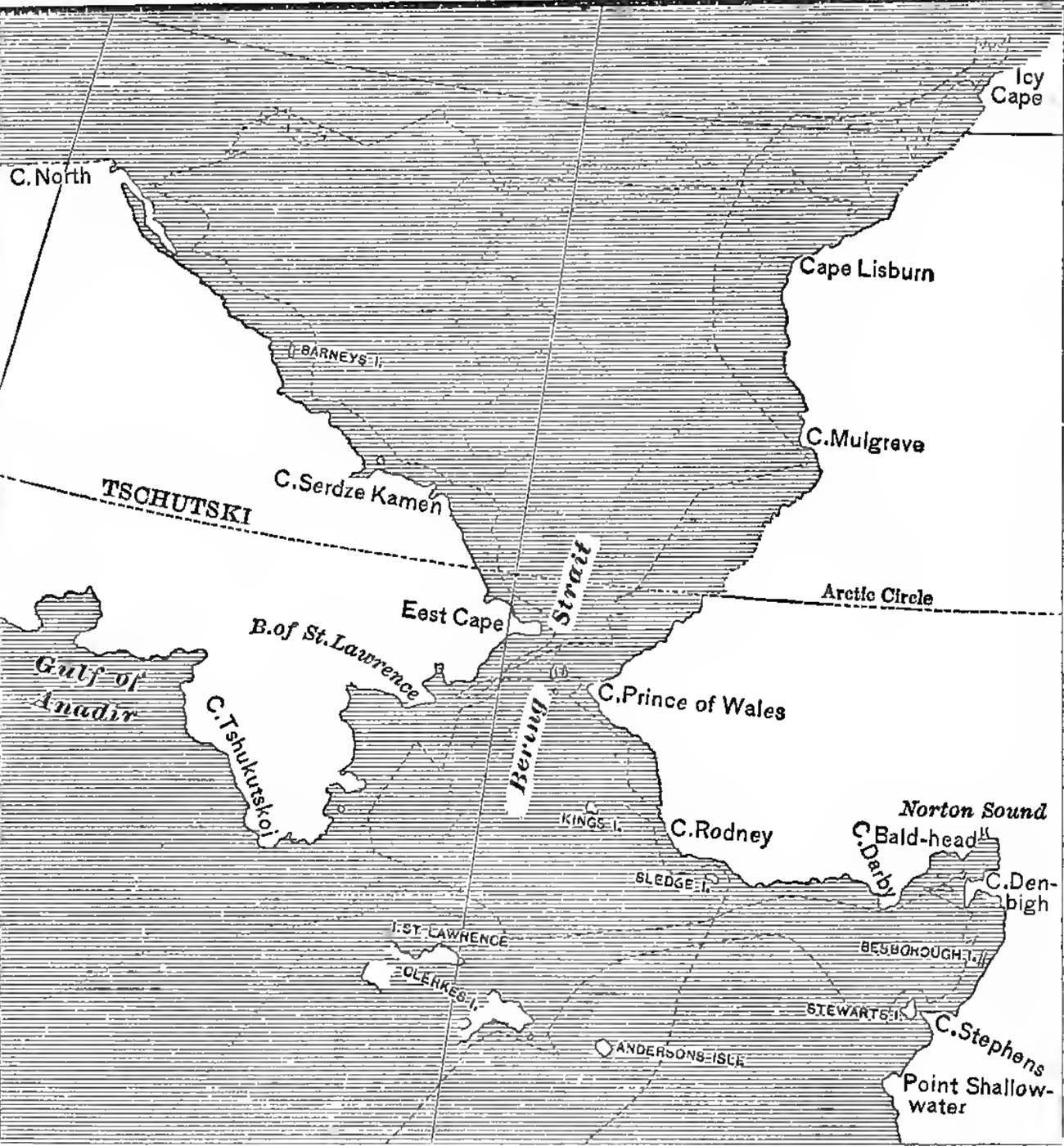
After
a brisk run across to the coast of Asia the ships returned to the Alaskan shore
and located Icy Cape, the eastern limit of the arctic cruise, Cape Mulgrave,
and Cape Lisburne, but ice barred further progress
on the American coast as well as on that of Asia. On the 29th Cook named Cape
North and concluded to return southward, postponing a further examination of
the Polar Sea for another season—which never came for him. On the evening of
the 2d of September the ships passed East Cape. The following day St Lawrence
Bay was revisited and examined, and on the 5th the ships were again headed for
the American coast. During the following day Norton Sound was entered and names
were applied to Cape Derby, at the entrance of Goloni Bay, and Cape Denbigh.
Cook
remained in this sound until the 17th of September in order to fully ascertain
the fact of his being then on the coast of the American continent and not on
the fabulous island of “Alaschka” represented upon Stsehlin’s map of the New Northern Archipelago.
Captain King had been intrusted with the examination
of Norton Bay, the only point where the existence of a channel was at all
probable.
On
leaving Norton Sound it was Cook’s intention to steer directly south in order
to survey the coast intervening between his last discovery and the point he
had named Shoalness on the Kuskokvim;
but the shallowness of that part of Bering Sea compelled him to run far to the
westward, and prevented him from seeing anything of the Yukon mouth, and the
low country between that river and the Kuskokvim, and
the island of Nunivak. After obtaining another sight of St Lawrence Island,
which he named Clark, Cook steered south-south-west and on the 23d sighted St
Matthew Island, which he named Gore.
On
the 2d of October Unalaska was sighted, and passing Kalekhtah Bay, called Egoochshac by Cook, the two ships
anchored in Samghanooda Bay on the 3d of October.
Both vessels were at once overhauled by the carpenters for necessary repairs,
and a portion of the cargo was landed for the purpose of restowing.
While
the ship’s companies were engaged in watering, repairing, fishing, and
gathering berries as an anti-scorbutic, a messenger arrived on the 8th with a
note written in Russian for the commander of each vessel, and a gift,
consisting of a salmon pie, baked of rye-meal. There was no one able to read the
notes, but, being now sure that some Russians resided in the immediate
vicinity, Cook caused a suitable return to be made in the shape of sundry
bottles of liquor. Corporal John Ledyard was sent with the returning messenger
to find the Russians, invite them to the anchorage, and obtain all available
information concerning their discoveries in American waters.
Ledyard’s
experience on this occasion has been described by himself and transmitted to
posterity by his biographer. He succeeded in his mission, passed a few days at
the settlement of Illiuliuk, and brought back three
Russian hunters, who were well received, and who freely imparted such
information as could be conveyed by signs and numerals. They promised to bring a map showing all the Russian
discoveries. On the 14th the commander of the Russian expedition in this
quarter arrived from a journey and landed near Samghanooda.
His name was Gerassim Grigorovich Ismailof.
The
usual civilities were exchanged and Cook had every opportunity of questioning his
visitor, but it is evident that the advantage was with the Russian, who learned
from the Englishman what was of the utmost importance to the Siberian
merchants, while he told what he chose, holding back much information in his
possession, for instance the visit of Polutof to
Kadiak in 1776 and the long residence at Unimak Strait of Zaikof,
who was even then at Umnak, close by. The corrected map of the islands shown to
Cook was probably the work of this same Potap Zaikof.
The most important correction he received for his own work was the existence of
the island of Unimak, which had been laid down on Cook’s chart as part of the
continent. Ismailof remained near Samghanooda until the 21st of October, and on his departure was intrusted with despatches for the lords commissioners of the
British admiralty which he promised to forward the following spring to Okhotsk
and thence to St Petersburg by way of Siberia.
Another
intelligent Russian whom Cook mentioned in his journal was Yakof Ivanovich Saposhnikof, in command of a vessel then lying at Unga.
The
accompanying reproduction of the chart showing Cook’s discoveries and surveys
as far as they fall within the scope of this volume will convey an adequate
idea of how much we owe to this eminent navigator.
On
the 26th of October, after a sojourn of twenty-three days, the Resolution and Discovery sailed from Samghanooda Harbor
for the Hawaiian Islands, where the gallant commander was to end his exploration
and his life.
In
1776 orders were issued in Spain to fit out another expedition to the north, to
continue and complete the discoveries of Cuadra made the previous year, but
the execution of the plan was delayed, and not until February 11, 1779, did two
vessels, the Princesa and the Favorita,
sail from San Blas, with Lieutenant Ignacio Arteaga in command, and Cuadra as
second.
On
the 28th of April the expedition, which had orders to attain a latitude of 70°,
found itself in latitude 54° 45', and on the 2d of May the vessels entered Bucareli Sound, Arteaga anchoring in a sheltered bay on the
south side, which he named Santa Cruz, and Cuadra exploring the north side of
the sound, but finally joining his commander in the Puerto de Santa Cruz on the
5th. As soon as Cuadra had reported to Arteaga for orders, it was resolved to
fit out an expedition of two boats for a thorough exploration of the interior
of the sound. The crews of both vessels were constantly employed in preparing
the boats, supplying wood and water, and assisting the officers in their
astronomical observations. On the 13th a solemn mass was celebrated on shore,
with accompaniment of music and artillery, a cross was erected in a prominent
place, and under waving of flags and salvos of musketry the country was taken
possession of in the name of the king, the savages gazing stolidly at this
insanity of civilization.
On
the 18th the two boats sailed from the Bahia de la Santissima Cruz, with a
complement of five officers, four soldiers, and twenty-four sailors. They were
provisioned for eighteen days. The result of the expedition was the earliest
and best survey ever made of the most important harbor of Prince of Wales
Island.
During
the absence of the boats on this errand the natives gathered in numbers about
the ships in the Bahia de la Santissima Cruz. The strict orders of the
commander to avoid a conflict, and to ignore small thefts, soon worked its evil
effect upon these children of nature, who could not understand leniency or unwillingness
to punish robbery and to recover losses, unless it was based upon weakness or
lack of courage. Working parties on the shore were molested to such an extent
that it became necessary to surround them with a cordon of sentries only five
paces apart, and sailors were robbed of their clothes while washing them. Under
these circumstances the return of the lanchas with their crews was
hailed with joy; but by this time over eighty canoes manned by a thousand
savages were in the bay and great caution was necessary to avoid hostilities.
Even the firing of cannon did not seem to frighten the Indians, and when a
canoe was struck by a ball and the inmates fell, the effect was only temporary.
Arteaga seized a chief in order to obtain the return of two sailors who had
been reported as held captive in the native village, but it was found that the
Spaniards had voluntarily joined the savages with the intention to desert.
During
the last days of June the two ships were moved across the sound to the bay of
San Antonio, and thence they finally sailed the 1st of July, taking a
north-westerly course along the coast. Mount St Elias was sighted on the 9th,
and a few days later Kaye, or Kyak, Island was named
Carmen. The next anchorage, probably Nuchek Bay, was
named Puerto de Santiago, and a boat expedition went to ascertain whether the
land was connected with the continent. The officer in charge reported that he
had convinced himself that it was an island. The usual forms of
taking possession were observed, being the third ceremony of the kind performed
upon nearly the same ground within a year—by Cook in 1778, by a party of Zaikof’s men, who had been despatched in a bidar from Cook Inlet, in June 1779, and again by Arteaga. Cuadra, in his
journal, expressed the conviction that a large river must enter the sea
between Carmen Island and the harbor of Santiago, thus correctly locating
Copper River, which both Cook and Vancouver failed to observe.
On
the 28th the ships put to sea once more, taking a south-westerly course,
without attempting to find a passage at the head of Prince William Sound as
Cook had done in the preceding year, and on the 1st of August they found an
anchorage formed by several islands in latitude 59° 8'. Formal possession was
again taken and the largest island of the group named Isla de la Regia. This
was the Cape Elizabeth of Cook, who had failed to notice its separation from
the continent. The Iliamna volcano on the west shore of Cook Inlet was sighted
from this point and named Miranda.
After
a short stay at this anchorage, Arteaga concluded to give up further
explorations and to sail direct for Cape Mendocino. The departure took place on
the 7th of August, and thus ended, so far as relates to Alaska, an expedition
which would have been of the greatest importance had it not been for the
English explorations of the year preceding. Arteaga and his officers could
know nothing of Cook’s investigations and believed themselves the first to explore
the region already visited by the Resolution and Discovery between Cross Sound and Cape Elizabeth, but even after deducting from the
result of their work all that may be
affected by Cook’s prior discovery, the careful survey of Bucareli Sound, in connection with Heceta’s and Cuadra’s prior
explorations, presents a basis for Spain’s claims to the coast region to latitude
58° so far as relative right of discovery is concerned, attended by the
ceremony of taking possession. A little more energy or ambition on Arteaga’s
part would have led to a meeting with the Russians and made the subsequent
expedition of Martinez and Haro unnecessary.
The
viceroy of Mexico declared himself highly pleased with the results of the
voyage, and advanced one step the rank of all the officers on both vessels. At
the same time he stated that no further discoveries in a northerly direction
would be undertaken for the present.
CHAPTER XI.COLONIZATION
AND THE FUR-TRADE.
1783-1787.
|