READING HALLTHE DOORS OF WISDOM |
 |
 |
 |
HISTORY OF THE RENAISSANCE
CHAPTER I
THE AGE OF DISCOVERY
AMONG the
landmarks which divide the Middle Ages from modern times the most conspicuous
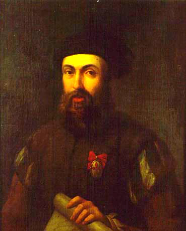
is the discovery of America by the Genoese captain Cristoforo Colombo in 1492.
We shall discuss in the next chapter the nature and consequences of this
discovery; the present deals briefly with the series of facts and events which
led up to and prepared for it, and with the circumstances in which it was made.
For Colombo’s voyage, the most daring and brilliant feat of seamanship on
record, though inferior to some others in the labor and difficulty involved in
it, was but a link in a long chain of maritime enterprise stretching backward
from our own times, through thirty centuries, to the infancy of Mediterranean
civilization. During this period the progress of discovery was far from
uniform. Its principal achievements belong to its earliest stage, having been
made by the Phoenicians, Greeks and Carthaginians before the Mediterranean
peoples fell under the dominion of Rome. By that time, the coasts of Southern
Europe and Asia Minor, and of Northern Africa, together with at least one,
perhaps more, among the neighboring island groups in the Atlantic, were known
in their general configuration, and some progress had been made in the task of
fixing their places on the sphere, though their geographical outlines had not
been accurately ascertained, and the longitude of the united terra firma of
Europe and Asia was greatly over-estimated. In consequence of this excessive
estimate Greek geographers speculated on the possibility of more easily
reaching the Far East by a western voyage from the Pillars of Hercules; and
this suggestion was occasionally revived in the earlier days of the Roman
Empire. Yet from the foundation of that Empire down to the thirteenth century
of our era, such a voyage was never seriously contemplated; nor was anything
substantial added to the maritime knowledge inherited by the Middle Ages from
antiquity. About the beginning of the twelfth century maritime activity
recommenced, and by the end of the fifteenth a degree of progress had been
reached which forced the idea of a westward voyage to the Far East into prominence,
and ultimately brought it to the test of experience.
These four
centuries, the twelfth, thirteenth, fourteenth, and fifteenth, constitute what
is called the Age of Discovery. The fifteenth century marks its greatest
development; and in the last decade of that century it enters on its final
stage, consequent on the discovery of America.
This period was
an Age of Discovery in a wider sense than the word denotes when associated with
maritime enterprise only. It beheld signal discoveries in the arts and sciences, the result of a renewed intellectual activity contrasting vividly with the
stagnation or retrogression of the ten centuries preceding. It witnessed the
rise and development of Gothic architecture, in connection with the foundation
or rebuilding of cathedrals and monasteries; the beginnings of modern painting,
sculpture, and music; the institution of universities; the revival of Greek
philosophy and Roman law; and some premature strivings after freedom of thought
in religion, sternly repressed at the time, but destined finally to triumph in
the Reformation. All these movements were in fact signs of increased vitality
and influence on the part of Roman Christianity; and this cause stimulated
geographical discovery in more than one way. Various religious and military
Orders now assumed, and vigorously exercised, the function of spreading
Christianity beyond the limits of the Roman Empire. By the end of the tenth
century, the Danes, Norwegians, Swedes, Poles, and Hungarians had already been
partly converted. During the twelfth century, the borders of the Roman faith
were greatly enlarged. Missionary enterprise was extended to the Pomeranians
and other Slavonic peoples, the Finns, Lieflanders,
and Esthonians.
The Russians had
already been Christianized by preachers of the Greek Church; Nestorians had
penetrated Central Asia, and converted a powerful Khan who himself became a
priest, and whose fame rapidly overspread Christendom under the name of
Presbyter or “Prester” John. Prester John was succeeded by a son, or brother, who bore the name of David; but
Genghis Khan attacked him, and towards the end of the twelfth century put an
end to the Christian Khanate. In the thirteenth century, Roman missionaries
sought to recover the ground thus lost, and Roman envoys made their way through
Central Asia, though the Catholic faith never obtained in these Eastern parts
more than an imperfect reception and a precarious footing. Traders and other
travelers brought the Far Fast into communication with Europe in other ways;
and Marco Polo, a Venetian adventurer who had found employment at the Great
Khan’s court, even compiled a handbook to the East for the use of European
visitors.
While inland
discovery and the spread of Christianity were thus proceeding concurrently in
the North of Europe and Central Asia, a process somewhat similar in principle,
but different in its aspect, was going on in the South, where the Mediterranean
Sea divided the Christian world from the powerful Saracens, or Mohammadans of Northern Africa. The conquests of this
people, of mixed race, but united in their fanatical propagation of the
neo-Arab religion, had been made when Southern Europe, weak and divided, still
bore the marks of the ruin which had befallen the Western Empire. The greater part
of Spain had fallen into their hands, and they had invaded, though fruitlessly,
France itself. Charles the Great had begun the process of restoring the
Christian West to stability and influence, and under his successors Western
Christendom recovered its balance. Yet the Saracen peoples still preponderated
in maritime power. They long held in check the rising maritime power of Venice
and Genoa; they overran Corsica, Sardinia, and the Balearic Islands. Nor was
the domination of these vigorous peoples confined to the Mediterranean. In the
Red Sea and on the East coast of Africa, frequented by them as far south as
Madagascar, they had no rivals. Eastward from the Red Sea they traded to, and
in many places settled on, the coasts of India, and the continental shores and
islands of the Far East.
That branch which
held Barbary and Spain was not likely to leave unexplored the Western coast of
Africa and the Canary Islands. It was on this coast that the principal work
achieved in the Age of Discovery had its beginnings; and although maritime
enterprise flourished at Constantinople and Venice, there can be little doubt
that these beginnings are due to the Saracens. The Moors, or Saracens of
North-west Africa, must have made great progress in ship-building and navigation
to have been able to hold the Mediterranean against their Christian rivals.
Masters of North Africa, they carried on a large caravan trade across the
Sahara with the negro tribes of the Soudan. It is certain that at the beginning
of the Age of Discovery they were well acquainted with the dreary and barren
Atlantic coast of the Sahara, and knew it to be terminated by the fertile and
populous tract watered by the Senegal river; for this tract, marked “Bilad Ghana” or “Land of Wealth”, appears on a map constructed
by the Arab geographer Edrisi for Roger II, the
Norman King of Sicily, about the year 1150. That they habitually or indeed ever
visited it by sea, is improbable, since it was more easily and safely
accessible to them by land; and the blank sea-board of the Sahara offered
nothing worthy of attention. The Italians and Portuguese, on the contrary,
excluded from the African trade by land, saw in Bilad Ghana a country which it was their interest to reach, and which they could only
reach by sea. Hence, the important events of the Age of Discovery begin with
the coasting of the Atlantic margin of the Sahara -first by the Genoese, in the
thirteenth and fourteenth centuries, then by the Portuguese, in the first half
of the fifteenth century and with the slave-raiding expeditions of the latter people
on the voyage to and in Bilad Ghana itself. The name
Ghana became known to the Genoese and Portuguese as “Guinea”, and the negroes
who inhabited it --a pure black race, easily distinguishable from the hybrid
wanderers, half Berber and half black, of the Western Sahara-- were called ‘Guineos’. Hitherto the Portuguese and Spaniards had
purchased blacks from the Moors; by navigating the African coast they hoped to
procure them at first hand, and largely by the direct process of kidnapping.
While we know
nothing of any voyages made by the Moors to Bilad Ghana, and very little of the expeditions of the Genoese explorers who followed
them, we possess tolerably full accounts of the Portuguese voyages from their
beginning; and these accounts leave us in no doubt that the nature and object
of the earliest series of expeditions were those above indicated. The
slave-traders of Barbary, until the capture of Ceuta by the Portuguese in 1415,
may have occasionally supplemented their supply of slaves obtained through
inland traffic, by voyages to the Canary Islands, made for the purpose of
carrying off the Guanche natives. Probably they also frequented the ports and
roadsteads on the Barbary coast outside the Straits. But the possession of Ceuta
enabled the Portuguese to gain a command of the Atlantic which the Moors were
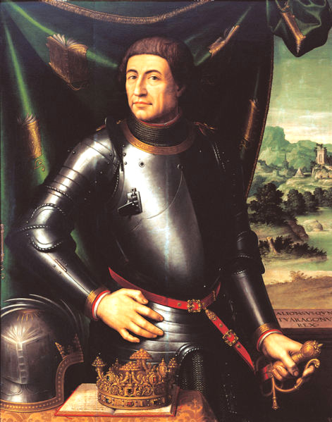
not in a position to contest. Dom Henrique, Infant of Portugal, and third
surviving son of King Joao I, by Philippa of Lancaster, sister of Henry IV,
King of England, became governor of Ceuta, in the capture of which he had taken
part, and conceived the plan of forming a Greater Portugal by colonizing the
Azores and the islands of the Madeira group, all recently discovered, or
rediscovered, by the Genoese, and conquering the “wealthy land” which lay
beyond the dreary shore of the Sahara. The latter part of this project,
commenced by the Infant about 1426, involved an outlay which required to be
compensated by making some pecuniary profit; and with a view to this Dom
Henrique subsequently resolved to embark in the slave-trade, the principal
commerce carried on by the Moors, over inland routes, with the Soudan and Bilad Ghana. Having given his slave-hunters a preliminary
training, by employing them in capturing Guanches in
the Canary Islands, he commissioned them in 1434 to pass Cape Bojador and make similar raids on the sea-board of the
Sahara. The hardy hybrid wanderers of the desert proved more difficult game
than the Guanches. For the purpose of running them
down, horses were shipped with the slave-hunters, but the emissaries of the
Infant still failed to secure the intended victims. Vainly, says the
chronicler, did they explore the inlet of the Rio do Ouro,
and the remoter one of Angra de Cintra “to see if they could make capture of any man, or hunt down any woman or boy,
whereby the desire of their lord might be satisfied”. In default of slaves,
they loaded their vessels with the skins and oil of seals. This poor traffic
was scarcely worth pursuing, and for several years (1434-41) the project of
conquering Bilad Ghana and annexing it to the
Portuguese Crown remained in abeyance.
Yet Dom Henrique
was not a mere slave-trader. The capture of slaves was destined to subserve a greater purpose : the conversion of Bilad Ghana into a Christian dependency of Portugal, to be
administered by the military Order of Jesus Christ. In Portugal this Order had
succeeded to the property and functions of the dissolved Order of the Temple,
and Dom Henrique was its Governor. His project was in substance similar to that
carried out by the Teutonic Order in conquering and Christianizing the heathen
Prussians; and the Order of Christ corresponded in its function to the Orders
of Santiago and Alcantara, which were actively
engaged in ridding Spain of the Moors. Dom Henrique’s scheme represents the
final effort of the crusading spirit; and the naval campaigns against the
Muslim in the Indian seas, in which it culminated, forty years after Dom
Henrique’s death, may be described as the Last Crusade. We shall see that
Albuquerque, the great leader of this Crusade, who established the Portuguese
dominion in the East on a secure footing, included in his plan the recovery of
the holy places of Jerusalem. The same object was avowed by Colombo, who
thought he had brought its attainment within measurable distance by the
successful voyage in which he had sought to reach the Far East by way of the
West.
A curious
geographical illusion served as a background and supplement to the scheme. The
Senegal river, which fertilizes Bilad Ghana, and is
the first considerable stream to the southward of the Pillars of Hercules, was
believed by Arab geographers to flow from a lake near those in which the Nile
originated, and was itself described as the “Western Nile”. The eastern branch
of the true Nile flowed through the Christian kingdom of Abyssinia; and if the
“Western Nile” could also be Christianized from its mouth to its supposed
source—no insuperable task, for Bilad Ghana had not
fallen under the sway of Islam—Christian Europe would join hands with Christian
East Africa, the flank of the Muhammadan power would be turned, and European
adventure would have unmolested access to the Red Sea and the ports of Arabia,
India, and China. How far in this direction the Infant’s imagination habitually
travelled, is uncertain. His immediate object was to subjugate and convert the
not yet Islamized heathen in the North-west of Africa, beginning with the
Senegal river, and to create here a great Portuguese dependency, the
spiritualties of which were, with the consent of the Holy See, to be vested in
the Order of Jesus Christ, and were destined to furnish a fund for the
aggrandizement of the Order, and the furtherance of its objects.
Dom
Henrique's project. 1426-41
In recent times
Dom Henrique has been named Prince Henry the Navigator, a title founded on the
supposition that his expeditions mainly aimed at the extension of nautical
enterprise for its own sake, or had for their conscious though remote object
the discovery of the sea-route to India and the westward exploration of the
Atlantic Ocean. It has even been stated that the town founded by him on the
southernmost point of the Sacred Promontory, the westernmost angle of which
bears the name of Cape St Vincent—a town now represented by the little village
of Sagres—was the seat of a school of scientific
seamanship, and that his aim was to train up for the national service a
continuous supply of intrepid and accomplished sailors, destined in the third
and fourth generation to perform the memorable feats associated with the names
of Da Gama and Magalhaes. All this must be dismissed
as illusory, and the picturesque title “the Navigator” is calculated to
mislead. There is nothing to show, or even to suggest, that Dom Henrique was
ever further away from Portugal than Ceuta and its immediate neighborhood, or
that he had formed any plans for the extension of ocean navigation beyond a
point long previously reached by the Genoese, or ever thought of the route
round the southernmost point of Africa as a practical route to India. A more
truthful clue to the aims of his life occurs near the beginning of his last
will, wherein, after invoking “my Lord God” and “my Lady Saint Mary for that
she is the Mother of Mercy”, he beseeches “my Lord Saint Louis, to whom I have
been dedicated from my birth, that he and all Saints and Angels will pray God
to grant me salvation”. The model of conduct and policy affected by Dom
Henrique was the heroic and sainted French King who had flourished two
centuries before. Louis, after ascertaining by disastrous experience the
impracticability of driving the Saracens from the Holy Land and Egypt, had
sought to convert the sultanate of Tunis into a
dependency of France as the first step in recovering northern Africa for
Christendom. In some respects the plan of Dom Henrique was easier of
achievement than that of Louis. Islam having not yet overspread Bilad Ghana, it would be far less difficult to conquer and
convert its undisciplined savages to the Gospel, than to drive a wedge into the
heart of Mohammadan North Africa by the conquest of
Tunis. Both schemes were late offshoots of the crusading spirit; Dom Henrique’s
plan was among its last manifestations. As in the case of the later Crusades,
this plan was largely inspired by political objects. The Villa do Infant on the
Sacred Promontory was destined to be the maritime centre of the united empire of Peninsular Portugal and Greater Portugal—the latter
comprising the Madeira group and the Azores, together with Bilad Ghana, and whatever else the Infante might annex to
the ancient dominion of Portugal and Algarve. It was a sacred spot; for hither
the Christians of Valencia had fled, seven centuries before, from the terrible
Abdurrahman Adahil, carrying with them the body of St
Vincent, from whose last burial-plane the westernmost promontory of Europe
thenceforth took its name.
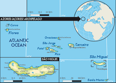
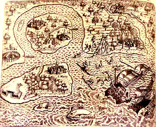
In 1441,
twenty-six years after the capture of Ceuta, and the year after Terceira, the
first among the Azores to be discovered, had been reached, a sudden impetus was
given to the Infante’s project. Anton Gonçalvez had sailed to the Rio do Ouro for sealskins and oil. Having secured his cargo, he landed with nine armed men
on the shore of the inlet, and after a desperate struggle with a solitary naked
African succeeded in wounding and capturing him. To this feat he added that of
cutting off a female slave from her party, and securing her also. Shortly
afterwards Nuño Tristan, a knight highly esteemed by
Dom Henrique, arrived at the Rio do Ouro with a
caravel, intending to explore the coast beyond Angra de Cintra in search of captives. Fired by the exploit
of Gonçalvez, Tristan landed, marked down a party of
natives, and after killing several captured ten men, women, and children,
including a personage who ranked as a chief. After exploring the coast, with no
further success, as far as Cape Blanco, Tristam followed Gonçalvez to Portugal, where they joyfully
presented to the Infant the long-desired first-fruit of his projects.
Chroniclers dwell complacently on the joy experienced by the Infant,
commensurate not to the value of the slaves actually taken but to the hope of
future captures, and on his pious rapture at the prospect of saving the souls
of so many African heathen. Dom Henrique now sought and obtained from the Pope
a special indulgence for all who should fight under the banner of the Order of
Christ for the destruction and confusion of the Moors and other enemies of
Christ, and for the exaltation of the Catholic faith. He further procured from
his brother Dom Pedro, regent of the kingdom, an exclusive right of navigation
on the West African coast, and a surrender of the whole of the royalties due to
the Crown on the profits of these voyages. A new stimulus was given to the
enterprise by the discovery that captives of rank could be held to ransom, and
exchanged for several slaves. In the following year (1442) Gonçalvez obtained ten slaves in exchange for two captured chiefs, and brought back a
little gold dust and some ostrich eggs. In the next year Tristam passed in his caravel beyond Cape Blanco, and reached the island of Arguin. Fortune favored him in an unusual degree, for he
returned with his caravel laden with captives to its full capacity. The success
of the enterprise was now assured, and in the next year it was prosecuted on a
more extensive scale. The people of Lagos, the port where the captured slaves
were landed, roused by the prospect of still greater gains, made preparations
for seeking them, by way of joint-stock enterprise, on a larger scale than heretofore.
The Infant licensed an expedition consisting of six caravels, the command being
given to Lanzarote, receiver of the royal customs at Lagos, and presented each
with a banner emblazoned with the cross of the Order of Christ, to be hoisted
as its flag. Lanzarote and his companions raided the coast as far as Cape
Blanco, shouting “Santiago! San Jorge! Portugal!” as their war-cry, and
ruthlessly slaying all who resisted, whether men, women, or children. They
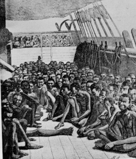
brought back to Lagos no less than 235 captives; the receiver of customs was
raised by the Infant to the rank of knight, and the wretched captives were sold
and dispersed throughout the kingdom. Large tracts, both of Portugal and Spain,
remained waste or half cultivated as a result of the Moorish wars: and the
grantees of these lands eagerly purchased the human chattels now imported in
increasing numbers.
The project of
Dom Henrique had now made an important advance. Its ultimate success appeared
certain; and the Infant resolved that a direct effort should be made to reach Bilad Ghana itself, through which the “Western Nile” rolled
its waters from the highlands of Abyssinia and the Christian realm of “Prester John”. A certain equerry was commanded to go with a
caravel straight for Guinea, and to reach it without fail. He passed Cape
Blanco, but was unable to resist the temptation of a profitable capture on his
route. Landing on one of the islands near the Bank of Arguin,
he and his men were surprised by a large party of natives, who put off from the
mainland in canoes, and killed most of the raiders, including their commander.
Five only returned to Portugal. Diniz Dias, an
adventurer of Lisbon, claimed about the same time to have passed the Senegal
river, to have sailed along the thirty-four leagues of coast which separate it
from Cape Verde, and on the strength of having on his way picked up a few
natives in canoes, to have been the first to bring back real “Guinea negroes”
for the Portuguese slave-market. How far his claim to this distinction is
sustainable, is left an open question by the authorities. The wave of African
enterprise was now steadily gaining strength. The Infant readily licensed all
intending adventurers, and the coast, long unfrequented by the European sailor,
swarmed with caravels. In 1445 twenty-six vessels, fourteen of which belonged
to Lagos, left that port under the command of the experienced Lanzarote,
specially commissioned to avenge the Infant’s unfortunate equerry who had
fallen as a protomartyr on the African shore,
carrying the Cross-emblazoned banner of the Order of Christ. Six of these
fulfilled the Infant’s direction to push on to the “River of Nile”, and land in Bilad Ghana. The palm-trees and other rich
vegetation, the beautiful tropical birds which flitted round their caravels,
the strange kinds of fish observed in the waters, gave promise of the
approaching goal; and at length the voyagers beheld the sea discolored by the
muddy waters of the Senegal to a distance of two leagues from land. Scooping
these up in their hands, and finding them fresh, they knew that their object
was attained, sought the river’s mouth, anchored outside the bar, launched
their boats, captured a few hapless negroes, and returned to Dom Henrique,
picking up more captives on the way, with the welcome intelligence that his
desires were at length accomplished, that the “River of Nile” had been reached,
and the way opened to the kingdom of Prester John.
In the nineteenth
year of his efforts to reach Bilad Ghana the Infant
thus saw them at length crowned with success; and his licensees pursued the
trade thus opened up so vigorously that in 1448, seven years after the capture
of the first natives, and three years after the Senegal had been reached, not
less than 927 African slaves had been brought to the Portuguese markets, the
greater part of whom, it is unctuously observed by Zurara,
were converted to the true way of salvation. The rich field of commerce thus
entered upon was rapidly developed by the continued exploration of the coast.
We have seen that even before the Infant’s emissaries anchored at the mouth of
the Senegal a navigator standing further out to sea claimed to have passed it,
and reached Cape Verde. The year in which the Senegal river was actually
reached (1445) was marked by another important advance. The Venetian captain Ca
da Mosto and the Genoese Antonio de Nola, both in the
Infant’s employ, passed beyond Cape Verde, and reached the Gambia river; the
Infant began also in this year the colonization of San Miguel, which had been
reached in the previous year, and was the second among the Azores Islands in
order of discovery. In 1446 Ca da Mosto and Antonio
de Nola not only discovered the four Cape Verde Islands, Boavista,
Santiago, San Filippe, and San Cristovao,
but passed Capo Roxo, far beyond the Gambia River,
and coasted the shore to an equal distance beyond Capo Roxo,
discovering the rivers Santa Ana, San Domingos, and
Rio Grande. From the coast south of Cape Verde new wonders were brought back to
Portugal. The Infant’s eyes were gladdened by beholding tusks of the African
elephant, and a living African lion.
How far southward
along the coast the Infant’s licensees had actually sailed at the time of his
death (1460), is uncertain. Could the distances reported by them as expressed
in nautical leagues be accepted as trustworthy evidence, they must have passed
the Bissagos and De Los Islands, and here reached the
latitude of Sierra Leone, only eight degrees north of the Equator. But the
estimates given in the chronicle, founded only on dead reckoning, are in excess
of actual geographical distances. We doubt whether before Dom Henrique’s death
Portuguese seamen had passed the tenth parallel of north latitude; and it is
known that in his last years the complete discovery and colonization of the Azores
group chiefly occupied his attention. Dom Henrique’s will, which specifies
churches founded by him in each of the Azores, in Madeira, Porto Santo, and
Deserter, as well as in various towns of Portugal and on the opposite coast of
Morocco, speaks of the great dependency of Guinea, which he had secured for the
Portuguese Crown, in general terms only.
He looked on it
as a certain source, in the future, of large ecclesiastical revenues. These,
following a common practice of the age, were settled by him, with the Pope’s
assent, on the military and religious Order of which he was governor. Guinea
was to be parceled into parishes, each having a stipendiary vicar or chaplain,
charged for ever with the duty of saying “one weekly mass of St Mary” for the
Infant’s soul. We find nothing about the circumnavigation of Africa, or the
extension of the enterprise to the Indian Ocean. Down to his death he probably
expected that a junction with the Christians of Abyssinia and the East would be
ultimately effected by ascending the Western Nile or Senegal River to its
sources, which were universally supposed to be near those of the Egyptian Nile.
This expectation, however, he associated with the remote future; his present
policy was to secure Guinea as a dependency for Portugal and a rich appanage
for the Order of Christ, by the construction of forts, the establishment of
parochial settlements, and the foundation of churches.
The economic
character of the Infant’s enterprise was felt, even in his lifetime, to be so
little in accordance with the character which history demands for its heroes,
that a contemporary chronicle of the Guinea expeditions, compiled by one Cerveira, is known to have been suppressed, and replaced by
the garbled work of Zurara, whose object it was to
write the Infant’s panegyric as a great soldier and eminent Christian, and as
the patriotic founder of the Greater Portugal which posterity would never cease
to associate with his name. As the enterprise assumed larger proportions, the pretence that the negro was captured and shipped to
Portugal for the salvation of his soul was abandoned. Even more valuable, for
commercial purposes, than negro slaves, were the gold and ivory in which the
tribes south of the Gambia River abounded. The Portuguese, who were now expert
slave-raiders, found that the reward of their enterprise was best secured by
disposing of their prey to the chiefs of other tribes, who were ready to give
gold and ivory in exchange. The Guinea trade, which assumed this character
almost exclusively soon after Dom Henrique’s death, was now farmed out to the
highest bidders. Alfonso V in 1469 granted it to one Fermin Gomes for five
years, at an annual rent of 500 crusados, on condition that the grantee
should in each year discover a hundred leagues of coast, or five hundred
leagues altogether during the term. Pursuant to these conditions Gomes pushed
the task of exploration vigorously forward. His sailors rounded Cape Palmas,
the south-western extremity of North Africa, whence the coast trends to the north-east,
passed the Ivory Coast, and reached what has ever since been known as the Gold
Coast in a special sense—the land of the Fantee, having as a background the
mountains of Ashantee; and here, a few years later,
Joao II founded the fort of San Jorge da Mina, the first great permanent
fortress of the Portuguese on the Guinea coast. Before the death of Affonso V (1481), his subjects had coasted along the
kingdoms of Dahomey and Benin, passed the delta of
the Niger, crossed the bight of Biafra, where the coast at length bends to
southward, discovered the island of Fermin do Po, followed the
southwards-trending coast-line past Cape Lopez, and reached Cape St Catherine,
two degrees south of the equator.
These
explorations proved that the general outline of Southern Africa had been
correctly traced on Italian charts dating from the preceding century; and the
last steps in the process of exploration, which finally verified this outline,
were taken with extraordinary rapidity. In 1484 Diego Cam reached the mouth of
the Congo, sailed a short way up the river, and brought back with him four
natives, who quickly acquired enough Portuguese to communicate important
information regarding their own country and the coast beyond it. Returning with
them in 1485, he proceeded some distance to the southward, but made no
extensive discoveries; nor was it until the following year that Bartolomeo
Dias, charged by Joao II with the task of following the continent to its
southern extremity, passed from the mouth of the Congo two degrees beyond the
southern tropic, and reached the Sierra Parda, near Angra Pequelia. From this point
he resolved to stand out to sea, instead of following the shore. Strong
westerly gales drove him back towards it; and he at length reached Mossel Bay, named by him Bahia dos Vaqueiros,
from the herdsmen who pastured their flocks on its shore. He was now on the
southern coast of Africa, having circumnavigated the Cape of Good Hope
unawares. From this point Dias followed the coast past Algoa Bay as far as the Great Fish River. Its trend being now unmistakably to the
north-east, he knew that he had accomplished his task. Returning towards the
Cape, to which he gave the name Cabo Tormentoso, or
Cape Tempestuous, he rounded it in the reverse direction to that which he had
at first intended, and returned to Portugal.
As the Portuguese
exploration of the African coast proceeded during sixty years, the objects with
which it was pursued were almost completely transformed; and it illustrates
perhaps more aptly than any other episode in European history the transition
from the ideas of the crusading age to those of the age of dominant commerce
and colonization. Dom Henrique’s conception of a “Greater Portugal” including
the island groups of the Atlantic and Bilad Ghana on
the Senegal River certainly recalls, and was probably founded on, the Mohammadan dominion which included Southern Spain, the
Balearic Islands, and Northern Africa, and which St Louis proposed to replace
by a Christian dominion equally comprehensive. To this strictly medieval
conception the Infant added some dim idea of a junction with the Christian
sovereign of Abyssinia, to be effected by ascending the Western Nile. Beyond
this point we have no reason to conclude that his imagination ever wandered.
The transformation began after his death. The new dominion called “Guinea” was
ascertained by a rapidly extending process of exploration to be of enormous
size; this modest province, as it had seemed in prospect, assumed the
proportions and character of a vast and hitherto unknown continent. Twenty-six
years of discovery, after the Infant’s death, revealed three times the length
of coast which had been made known in the course of a considerably longer
period during his lifetime; and the Portuguese sailors had now been brought
within measurable distance of the Red Sea and Persian Gulf—of India, China, and
the Spice Islands. Europe’s commerce with the East—an object far exceeding in
importance the conquest of Guinea—was evidently within the grasp of Portugal.
Ten years elapsed, and a transcendent effort of seamanship had to be made,
before actual possession was taken of the prize. Meanwhile, the geographical
knowledge attained during these twenty-six years wrought like a ferment in the
minds of European observers. It was felt that the little kingdom of Portugal
had effected something like a revolution in the intellectual world: and the
ideas inspired by this change, while the existence of the New World, called
afterwards America, was as yet unsuspected, are admirably expressed in an
epistle addressed to Joào II by Angiolo Poliziano, professor of Greek and Latin literature at
Florence. The foremost scholar of the Renaissance tenders to the Portuguese
King the thanks of cultivated Europe. Not only have the Pillars of Hercules
been left behind, and a raging ocean subdued, but the interrupted continuity of
the habitable world has been restored, and a continent long abandoned to
savagery, representing one-third of the habitable world, has been recovered for
Christianity and civilization.
What new
commodities and economic advantages, what accessions to knowledge, what
confirmations of ancient history, heretofore rejected as incredible, may now be
expected! New lands, new seas, new worlds, even new constellations, have been dragged
from secular darkness into the light of day. Portugal stands forth the trustee,
the guardian, of a second world, holding in the hollow of her hand a vast
series of lands, ports, seas, and islands, revealed by the industry of her sons
and the enterprise of her Kings. The purpose of Politian’s epistle is to
suggest that the story of this momentous acquisition should be adequately
written while the memorials of it are yet fresh and complete, and to this end
he offers his own services. Its significance for ourselves lies in the fact
that his admiration is couched in terms which would apply with equal or greater
propriety to the impending discovery of the western continent. The existence of
America was as yet unsuspected: and the mental fermentation produced in Europe
by the Portuguese voyages quickly led to its discovery. To cosmographers this
fermentation irresistibly suggested the revival of an idea evolved eighteen
hundred years previously by Greek geographers from the consideration of the
recently ascertained sphericity of the earth and the
approximate dimensions of its known continental areas. A few days' sail, with a
fair wind, it had been long ago contended, would suffice to carry a ship from
the shores of Spain, by a westward course, to the eastern shores of Asia. The
argument had never been wholly lost sight of; and the revival of science in the
thirteenth century had once more brought it into prominence. Roger Bacon had
given it a conspicuous place in his speculations as to the distribution of land
and ocean over the globe. One is even tempted to think that those adventurous
Genoese who in 1281 passed the Straits of Gibraltar with two vessels, intending
to make their way to the Indies, and were never again heard of, prematurely
sought to bring it to the test of experience; but the better opinion is that
they merely proposed to circumnavigate South Africa. As the African coast was
progressively explored by the Portuguese and laid down on the chart, the
realization of the idea of reaching the East by way of the West became a
practical matter. While Gomes was pushing forward the exploration of Southern
Guinea, a canon of Lisbon, on a visit to Florence, consulted Toscanelli, the most celebrated of Italian physicists, on
the feasibility of such a voyage, and brought back to Affonso V a verbal opinion favorable to it; and this opinion was shortly confirmed by a
letter and a chart on which the proposed westward course was laid down. Twelve
years were yet to pass before Dias reached the Cape of Good Hope; the time for
testing the scheme had not fully come. But as the Portuguese ships drew nearer
to their goal, the western voyage more and more attracted attention; and the
idea gained countenance through the extension of maritime enterprise further
and further into the unknown westward expanses of the Atlantic Ocean, pursuant
to the development of a Greater Portugal according to Dom Henrique’s design.
Atlantic
island exploration. Antilha and Brazil. 1450-92
Before his death
the Infant had provided for colonization and church-building in each island of
the Azores group. Beyond the Azores, medieval imaginative cartographers dotted
the unknown Atlantic with numerous islands, some of which were distinguished by
positive names. Scholars pondered over Pliny’s account, based on a legend
stated at length in Plato’s Timaeus, of the
great island Atlantis, believed to have formerly existed far to the westward of
Mount Atlas, from which both island and ocean derived their familiar name.
Later legends described various existing islands as having been actually
reached in historical times. Arab sailors had discovered the Isle of Sheep;
Welsh emigrants had peopled a distant land in the west; seven bishops, fleeing
before the Muhammadan invaders, had sailed westward from the Spanish peninsula
and founded Christian communities on an island which thenceforward bore the
name of the Isle of the Seven Cities. Saint Brandan, an Irish missionary, had
reached another rich and fertile island, traditionally named from its
discoverer; another island, believed to lie not far to westward of the Irish
coast, bore the name “Brazil”. Far to the north-west, a perfectly truthful
historical tradition embodied in the Sagas of Iceland, and repeated by
geographers, placed the New Land or New Isle discovered in the tenth century by
Northmen from Iceland, and by them named “Vineland”, from the small indigenous
American grape. All the Azores Islands had been colonized in the Infant’s
lifetime. As after his death the Guinea coast was revealed in ever-lengthening
extent, other adventurers dared to sail further and further westward into the
unknown expanses of the Atlantic. The name commonly given among the Portuguese
seamen to the object of such voyages was Antilha,—a
word by some antiquaries derived from the Arabic, though more probably a
compound Portuguese word meaning ‘opposite island’, or ‘island in the
distance’, and denoting any land expected to be pictured on the horizon. Year
by year vessels from Lisbon scoured the sea beyond the Azores in search of Antilha or Antilhas. In 1486, the
year in which Diaz reached the Cape of Good Hope, Femora Dolmos,
lord of Terceira, procured from Joao II a grant of Antilha to his own use, conditionally upon its discovery by him within two years. The
terms in which it was on this occasion described clearly illustrate the
contemporary idea concerning it—“a great isle, or isles, or continental coast”.
The possibility of reaching Eastern Asia, with its continental coast and
numerous islands, by a western passage was no doubt present to the minds of
those who framed this grant. But Antilha was by no
means conceived of as part of the Asiatic coast, or as one of the adjacent
islands. It was believed to lie nearly midway between Europe and Asia, and
would form the voyager’s half-way station on his passage to and fro; hence its
discovery was looked forward to as the first step in the achievement of the
westward passage. The description of it as “a great isle, or isles, or
continental coast” perhaps connects it with the New Land or Vineland of the
Northmen, which was represented as a continental shore bordering the northern
expanses of the Atlantic, with islands of its own adjacent to it. Some such
conception of the halfway land was probably present to the mind of John Cabot,
who reached Labrador and Newfoundland by taking a northward route, passing by
or near to Iceland, the maritime base of the Northmen’s discovery of Vineland.
The more usual
conception of Antilha was that of a large solitary
island in the midst of the Atlantic in more southern latitudes: and it had been
so indicated on the chart sent by Toscanelli for the
guidance of Portuguese explorers in 1474. Similar notions were entertained as
to the islands of St Brandon, and Brazil, by the seamen of Bristol, who during
these years were scouring the Atlantic further to the northward, with no less
eagerness than those of Lisbon. The general object of all these voyages was the
same. It was to find some convenient halfway island as an outpost of further
exploration in the direction of the Far East, and a station in the new
commercial route about to be established. Year by year sailors from Bristol
sailed from Dingle Bay, on the southwest coast of Ireland, in search of Brazil
Island, pursuing the same plan as that of the Portuguese who sailed from Lisbon
in quest of the Antilha, or Antilhas.
No record exists of the course taken in these voyages: but we can have little
doubt that after sailing for some distance due west the course was changed, and
a zigzag mode of exploration was adopted, which could lead to nothing but
failure. The explorer, ever haunted by the suspicion that he had left Antilha behind him, would at length change his course, and
look out in the reverse direction. It is easy to see that the first condition
of a westward voyage which was to produce a positive discovery was definitively
to abandon this fruitless method, and to sail due west from the Old World;
Colombo was the first to reach America because he was the first to take this
view of the conditions of his task. His plan, early determined on and
tenaciously adhered to, was to abandon Antilha and
Brazil, and to assume that between the Azores and the eastern shores and
islands of Asia there were no lands to be discovered, and that there was
accordingly nothing to be done but to cross the trackless Atlantic by as direct
a course as possible. This perfectly accurate forecast, and the firmness with
which he adhered to the plan founded upon it, rank among the most conspicuous
indications of Colombo’s greatness.
The execution of
such a plan involved great preparations. Three ships, provisioned for twelve
months, represented Colombo’s estimate of what was necessary; and whatever
power should accept his offer to sail with such an equipment for the eastern
shores and islands of Asia, was destined to acquire the substantial sovereignty
of that New Continent whose existence remained as yet unsuspected. Both
Cristoforo and Bartolomeo Colombo had been from their youth in the maritime
service of Portugal, and Cristoforo had married a Portuguese wife. In early
life he had found constant employment in the Guinea voyages; having also sailed
to Bristol, and from Bristol far beyond Iceland, he knew the entire field of
Atlantic navigation from the Arctic circle to the equator. It was natural that
his first proposal for making a westward passage to the East should be made to
the King of Portugal. It was equally natural that the proposal should be
rejected. The circumnavigation of Africa was nearly accomplished; of this route
to the wealthy East the Portuguese would enjoy a practical monopoly, and it
could be effectively defended. Contemporary explorations in the Western
Atlantic left doubtful the question whether any land, island or continent,
existed in this direction within practical sailing distance. Even if the
westward passage were successfully accomplished, it was manifest that Portugal
would be unable to monopolize it, and that the discovery must ultimately enure for the benefit of the stronger maritime nations of
Western Europe. Considerations of this kind sufficed to ensure the rejection of
Colombo’s proposals by the prudent counselors of Alfonzo V; but the projector
always remembered his repulse with bitter resentment, and mockingly remarked,
in after years, that the Almighty had rendered Affonso “blind and deaf to the miracle about to be wrought by Him through the agency of
the King and Queen of Castile”. Having failed in the land of his adoption,
Colombo carried his project to the republic of which he was born a citizen,
where it met with no better reception. The interest of Genoa was to keep the
Oriental trade in its existing overland channels; and the same consideration
prevailed with the rival city of Venice, to whose Signoria the projector made his next application.
It was now clear
that the project would only be taken up by some power which had no vested
interest in maintaining the existing state of commercial intercourse—some power
on the western sea-board of Europe, for which the establishment of the proposed
route would open up a new field of enterprise. Such powers were Spain, England,
and France; and Colombo astutely bethought himself of applying simultaneously
to the two former, and playing them off against each other until one of them
definitely accepted his proposals. He carried his plan in person to Spain, and
commissioned his brother Bartolomeo to lay it before Henry VII of England
(1485). Accidents, delays, and circumstances of various kinds put off for four
years longer the momentous issue which of these two powers would accept the
plan and obtain the inheritance of the unknown New World. Fortune inclined the
balance in favor of Spain. When a message at length arrived summoning Colombo
to a conference with the King of England, he had already come to a substantial
agreement, though he had not yet concluded all the terms of his bargain, with
Ferdinand and Isabella. Bartolomeo Dias, at this juncture, had just returned
from his cruise on the southernmost shore of Africa. On April 17, 1492, the
contract was signed which secured to Colombo, not merely the usual rewards of
maritime enterprise accorded to adventurers in Portuguese practice, but some
additional advantages of a personal nature, including the dignity of Admiral
and Viceroy in the islands and continental provinces to be acquired by him for
the Castilian Crown. On August 3 he sailed from Palos; on September 6 he
quitted the roadstead of Gomera; and three days later
the breeze sprang up which carried his three caravels successfully across the
Atlantic.
At this point it
will be convenient to glance for a moment at the existing state of geographical
knowledge, which had become considerably augmented during the fifteenth
century. With one vast deduction—namely, the northern and north-eastern coasts
of Europe and Asia from the North Cape of Norway eastward as far as Northern
China, including Northern Russia and Siberia—the Old World had now been
completely revealed. To Europeans, indeed, the contour of Southeastern Africa
remained unascertained. Its true shape, nevertheless, must have been known to
the Arab seamen who navigated the Indian ocean: many of these were also well
acquainted with the Eastern Archipelago, known to Europeans only as passengers
or overland travelers, as far as a point near the western end of New Guinea.
Greenland was known, and in Northern and Western Europe the discovery of
“Vineland” by Norse adventurers five hundred years previously was still a
familiar tradition. From the point of view of scientific geography all this
amounted to little. Not more than one-fourth of the earth’s surface had been
laid down on the map. Colombo’s first expedition did no more than determine the
breadth of the Atlantic in the latitude of the northern tropic, and prove that
a numerous group of islands, from which the proximity of a continental shore or
Terra Firma might fairly be inferred, existed on the other side. His subsequent
voyages changed this inference into certainty: but the fact that the Terra
Firma here encountered was a continent hitherto unknown, though its northern
parts had been reached by the Northmen five centuries before, was never
ascertained by him, and to the day of his death, fourteen years later, he
believed himself to have merely reached the eastern parts of Asia. In fact, he
was nearly at the opposite meridian, and a hemisphere raised its immense dome
between. Colombo’s five weeks’ voyage, nevertheless, proved the great
turning-point in man’s slowly-progressing knowledge of the globe. Eighteen
years after his death the general figure of the New World had been ascertained,
its southernmost point rounded, the Pacific crossed, and the first furrow
ploughed by a ship’s keel around the sphere. Small as was his own actual
contribution to geographical knowledge, it was his energy and enterprise, and
his alone, which rapidly forced on a conception of geography sufficiently
accurate to last with little improvement to the time of Cook, nearly three
centuries later.
The consequences
of this voyage must ever render all its details and circumstances matters of exceptional
interest; but it is impossible here to enter into them. On October 12, 1492,
Colombo landed on one of the Bahama Islands from his ship's boat, wearing the
costume of Admiral of Castile, and holding aloft the Castilian banner; and in
the course of a three months' cruise he visited Cuba and Haiti, and gained a
general notion of the West Indian archipelago. The tidings of his voyage were
joyfully received both in Spain and at Rome; and a petition was preferred to
Pope Alexander VI for a confirmation to the Spanish Crown of the district
comprising the newly-found islands, subject only to the rights of any Christian
communities which might happen to be included in it. In answer to this two
separate bulls were issued. One simply contained the confirmation desired; the
other was framed in similar terms, but limited the area of Spanish enterprise
to a meridian line to be drawn one hundred leagues west of the Azores and the
Cape Verde Islands. The last, often singled out as a prominent illustration of Romish arrogance, was in fact only a suggestion intended to
prevent disputes, probably due to some official of the papal chancery. It was
never acted on by the parties, and was withdrawn in the same year by the Pope
himself. For by a third bull, dated September 25, 1493, and superseding
previous ones, the entire field of oceanic enterprise was expressly declared to
be open to both nations, on the understanding that Spain should approach it by
the westward passage only, and not infringe Portugal’s monopoly of the African
coast. The parties, thus remitted to their original rights, fixed as the
boundary of their areas of enterprise a meridian of their own selection, 370
leagues west of the Cape Verde Islands, and intended to mark a midway line
between the Azores, the westernmost of Portugal’s possessions, and the new
islands in the West Indies, supposed to be the easternmost parts of the Spanish
acquisitions. The action of the Holy See in assuming to partition the globe
between the sovereigns of Spain and Portugal has often been ridiculed. Such
ridicule, it will be seen, is misplaced; and the papal claim to universal
dominion, in its practical bearings, represented nothing more than a simple
counterclaim against the more ancient and equally extravagant pretensions of the
successors of Mohammad.
A second voyage
made by Colombo in 1493, a third in 1498, and a fourth in 1502, added
something, but not much, to the sum of his discoveries; and his administration
as governor of the new Spanish acquisitions was only remarkable for
demonstrating his utter incapacity for the post. Naturally enough, his
conception of his duties and of the purpose which the new possessions of Spain
were destined to serve, was based on the policy of the Portuguese on the coast
of Guinea. Gold, and slaves as a means to gold, and as the only product
immediately procurable and readily exchangeable for gold, were the only
commodities worth carrying to Europe; and the scantier the supply of the
former, the greater was the necessity for pushing the quest of the latter. The
true riches of the Indies, Colombo wrote, are the Indians. The wretched
natives, unable to procure the small quantity of gold demanded of them as a
poll-tax, were provoked to resistance, and then captured and shipped by him in
great numbers to Europe to be sold in the market of Seville. But the feeble and
intractable Indians proved of little value as laborers; and it was at length
ordered that this revolting traffic must cease. The Spanish adventurers who
accompanied him frustrated his plans and procured his recall; and at his death
in 1506, fourteen years after his unique nautical achievement, the first seaman
in Europe, who might in half that time have revealed the whole American coast,
had only added to the map the West Indian archipelago and the coasts of
Honduras, Nicaragua, Costa Rica, Darien, and Paria in
Venezuela. In a few years his name was almost forgotten; and, by a strange
freak of fortune, one Americo Vespucci, a man of
mercantile pursuits who happened more than once to visit the New World and
wrote accounts of his adventures, was credited by an ignorant public with
Colombo's discovery, and from him the new continent received its name.
Meanwhile, the
success of Colombo’s first and second voyages urged on the Portuguese the necessity
of prosecuting to its conclusion their own national enterprise. Dorn Manuel the
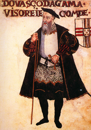
Fortunate now succeeded to the throne (1495); and Vasco da Gama, a young seaman
who had been selected by Joao II, after the return of Diaz, to command the
expedition which was to complete the work of sixty years by carrying the
Portuguese flag round the newly-discovered southern cape to the shores of
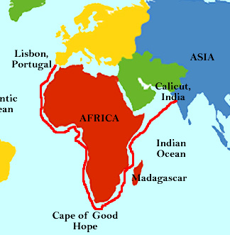
India, was commissioned to undertake the task. A voyage from Lisbon to India
was by far the greatest feat of seamanship ever attempted; even its first
portion, the voyage to the Cape of Good Hope, which it was proposed to make as
directly as possible from the Cape Verde Islands across the open ocean,
avoiding the circuitous route by the Guinea coast and the mouth of the Congo, was
a far greater undertaking than the voyage of Colombo. The discoverer of America
had but to sail 36 days, with a fair wind, to traverse the 2,600 miles between Gomera and the Bahamas. The distance from the Cape Verde
Islands to the Cape was 3,770 miles. It was impossible to make the voyage by
great-circle sailing. Contrary winds and currents made it necessary to shape a
course curving to the extent of almost half a circle, the direct line forming
the chord of the arc; and 93 days elapsed after da Gama had left the Cape Verde
Islands before he reached the coast of South Africa.
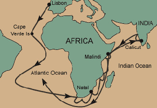
Leaving Lisbon on
July 8, 1497, and the Island of Santiago, the southernmost of the Cape Verde
group, on August 3, he first sighted land on November 4, and on the 8th
anchored in the bay of St Helena, in the land of the Hottentots, where he
remained eight days, careening his ships and taking in wood. Quitting his
anchorage on the 16th, he doubled the Cape on the 22nd, and three days later
reached Mossel Bay, where he remained thirteen days.
Resuming his course on December 8, he eight days afterwards passed the mouth of
the Great Fish river, the last point reached by Diaz, and was now in waters
never before traversed by European vessels. Struggling against the Agulhas
current, which had baffled his predecessor, he on Christmas Day reared the
roadstead which from that circumstance obtained the name of Port Natal. After
making halts in the bay of Lourenco Marques, and at the mouth of the Kiliman river, da Gama once more stood out to sea, and on
March 2, 1498, anchored in the roadstead of Mozambique. He had now effected the
desired junction of the West with the East; for the Mohammadan population here spoke the Arabic language, and through his own interpreters he
could freely communicate with them.
Da
Gama at Calicut. 1498
From this point
da Gama’s task was easy. He had entered a field of navigation known in all its
parts from remote times, and familiar ground to resident Mohammedan seamen and
traders, who received him amicably and furnished him with pilots. From
Mozambique he proceeded to Mombasa, where he fell in with non-Mohammadan residents, supposed by him to be Christians, but
in reality Banyans of India. A still larger “Christian” population of the same
nation was found in the port of Malindi. Here the
adventurers were furnished with a “Christian” pilot, who conducted them safely
across the Indian Ocean to Calicut, off which place da Gama anchored on May 20,
ten months and twelve days after leaving Lisbon. Calicut was the great emporium
of Arab trade. It was the chief among the many ports of the Malabar coast,
whence Europe drew its supplies of pepper and ginger. Here Mohammadan merchants purchased cinnamon brought from Ceylon and spices from the Molucca
Islands, which they carried to the port of Jiddah in
Arabia, and then to the port of Tor in the Sinaitic peninsula, whence they were carried overland to Cairo. Here they were shipped
down the Nile to Rosetta, and the last stage of transport was performed on
camels to Alexandria, where they were purchased by European merchants. At all
these places duties had to be paid, in consequence of which the cost of the
merchandise was quadrupled; and large profits could be reaped by merchants who
carried them directly from the East to Western Europe. There was another trade
route to Europe by way of the Persian Gulf, and so through Syria to Aleppo and
Beirut.
Although frequent
wars were waged between the native princes of the Malabar coast, they all
maintained a good understanding with the Muslim sailors and traders, and many
of the latter permanently resided on the Malabar coast and in the Far East. The
arrival of the Portuguese was not altogether unexpected. Their intention of
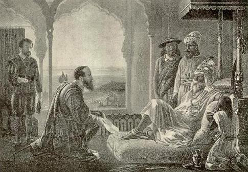
penetrating the Indian Ocean was well known; and on his arrival da Gama
pretended to be in search of some missing vessels of his squadron. Having
landed to enquire concerning them, he asked permission to trade, which was
granted. Meanwhile the Muslim residents intrigued with the native prince,
entitled the Samori, or Zamorin,
hoping to deal the Portuguese a crushing blow on the very threshold of their
undertaking. Representing the new-comers as mere marauders, they so far
succeeded as to induce the Zamorin to detain da Gama
and some of his companions as prisoners. He barely himself escaped
assassination; but a good understanding was at length restored, and the
Portuguese commander, after taking in a valuable cargo of pepper, ginger,
cinnamon, cloves, and nutmegs, besides rubies and other precious stones, sailed
on his return voyage on August 29, 1498, and in September 1499 at length made
his triumphal entry into Lisbon. Besides the merchandise which he secured, he
brought back precise information concerning the coasts of India as far as
Bengal, Ceylon, Malacca, Pegu, and Sumatra.
Thus was the way
opened for Europe's maritime invasion of the East; a process in modern history
perhaps of even greater importance than the European occupation of the New
World. Ever since da Gama's great voyage Southern and Eastern Asia, comprising
then as now the most populous nations on the globe, have been gradually falling
under the sway of the European powers, who have first appropriated their
foreign trade, making permanent settlements on their coasts in order to secure
it, thence advanced to controlling their administration and usurping their
government, and in some varying degree have succeeded in the more difficult
task of gradually changing their habits of life and thought. In all this
Europeans have been following in the footsteps of the Mohammadans of Western Asia and Northern Africa; and these had inherited their commercial
sphere from remote antiquity. Greek tradition even ascribed the invention of
ocean navigation to the aboriginal Eritreans, who had ploughed the Red Sea long
before Phoenicians and Greeks ventured to cross the Mediterranean; and ancient
ethnology distinguished these from the Semitic adventurers who in historical
times had colonized the islands on the southern coast of Arabia, and not only
traded by sea along this coast in its entire length, but frequented the
adjacent shores of Africa, and regularly crossed the mouth of the Persian Gulf
with the monsoon in search of the commodities of Western India.
The establishment
of Islam gave a new and powerful stimulus to all Arabian enterprise. By the end
of the fifteenth century there existed from the Red Sea to Japan a valuable and
well-organized commerce, mainly in the hands of Arabian or other Muslim seamen
and merchants. For the effect of the propagation of Islam had been to bring to
the field of Asiatic trade a crowd of adventurers of many nations, many of whom
were Turks of Anatolia or Europe. Others were Greeks, Albanians, Circassians, and other Levantines of European descent who
had abandoned the Christian faith for gain, and had brought to the Muslim
sailors and merchants of the Eastern ocean the knowledge and experience of the
Mediterranean peoples. These were generally known in India and the Far East as
‘Rumes’ (Arab. Rumi, a Greek); and Muslim opponents
found in the East by the Portuguese thus included not only true Arabs, whether
of Arabia, Africa, or India, generally known as “Moors”, but large numbers of
Turks and ‘Rumes’, whose European experience and
connection greatly aided the Moors in their resistance to the European maritime
invasion.
The course of
trade in these seas was not exclusively from west to east and back again. From
very early times a maritime commerce had been carried on in the reverse
direction; and the meeting-place of the two trades was the port of Calicut.
Hither came, once a year—for only during the summer were the Chinese seas
navigable for Chinese vessels—a large trading fleet from the ports of China.
The huge Chinese junks, with their fixed sails of matted reeds, never lowered,
even in harbor, and mainly propelled by oars of immense length, and having on
board gardens of growing vegetables, and large chambers for the ships’ officers
and their families, so that each was as it were a floating town, were objects
of curious interest to the Arabian sailors. The largest were reputed to carry a
thousand persons, and each was attended by three smaller craft for the purpose
of loading and unloading. It was natural for the Arabs, who had already secured
a part of the Indian coasting trade, to push their way towards the Far East,
and to claim a share in the trade of China and the Spice Islands. They found a
convenient station in the port of Malacca, which in their hands quickly became
the second great emporium of the Eastern trade. Nor did they rest here. Making
their way to the ports of China itself, they were amicably received, and
allowed to form settlements of their own. Many such settlements, each having
its resident magistrate and Sheikh ul Islam, existed
hard by the chief Chinese ports, and others were scattered through the Eastern
Archipelago. Malacca became the western outpost of the Far-Eastern trade thus
developed. Hither were brought the cloves of the Moluccas, the mace and nutmeg
of Banda, the sandal wood of Timor, the camphor of Borneo, and many other
spices, drugs, dyes, and perfumes from Java, Siam, China, and the Philippine
Islands, all of which could be purchased here more cheaply of the resident Arab
merchants than of those of Calicut, who obtained them in the ancient course of
trade from the Chinese fleet. Hence the sailors of Africa and Arabia, at the
arrival of the Portuguese, already resorted directly to Malacca for the produce
of the Far East, and Calicut became chiefly a market for the cinnamon of
Ceylon, and the ginger, pepper, and miscellaneous commodities of Malabar
itself. The ports of Arabia, and the Arab settlements in Eastern Africa, were
the inlets through which the produce of India and the Far East were finally
dispersed; and large quantities found their way through Suez, Jiddah, Mascot, and Hormuz, to the markets of Europe. It
thus appears that the area of the Eastern trade naturally fell into two divisions,
the mouth of the Persian Gulf marking the partition. Eastward of this lay the
area of export, westward the area of import. Hence the fact that the
Portuguese, having rounded Southern Africa, made straight for Calicut, the
outpost of the exporting area. The ideas and expectations with which they
approached this immense and unique field of enterprise were tinged with the
arrogance of prolonged success. It was necessary, as a means to making
themselves masters of the Eastern trade, before all else, not only to prove
themselves masters of the Asiatic seas, but to be able to defy resistance on
land, and to hold by military force whatever positions it might be desirable to
occupy. For these purposes such demonstrations of force as had availed them on
the African coast were insufficient. Society in the East rested everywhere on a
military basis. The native Asiatic princes universally possessed numerous and
not ill-equipped armies, though ill-supplied, or not at all, with firearms. By
sea the Arabs and Rumes were more formidable.
Wherever maritime trade exists it must defend itself against pirates; and
piracy was rife on all the Indian and Chinese shores. Hence the larger vessels,
both on the Malabar coast and on that of China, were usually manned with
fighting men, and those of the Arabs and Rumes occasionally carried large guns. The Oriental fleets, if assembled in one
place, would have immensely outnumbered the ships capable of being sent against
them by Portugal. But in regard to construction, equipment, and the art of
navigation the Portuguese had greatly the advantage. Even the Arabs knew
nothing of the art of using a vessel mainly as a military machine, much less of manoeuvring and combined action for attack, defence, pursuit, and co-operation with troops on land.
Eastern vessels, indeed, were scarcely capable of being so employed. The hard
woods used in constructing them forbade the use of iron nails, and their heavy
planks were rudely made fast with cocoa-nut cordage and wooden pins. Steering
gear and ground-tackle were of a rudimentary sort: even a moderate gale
rendered the ship scarcely manageable, and the guns were useless except at
close quarters. The Portuguese, who inherited the naval experience of two
thousand years, had become through their African voyages the best seamen in
Europe, possessed ships of the newest type, and attacked the Arabian vessels
with the confidence begotten of their maritime successes against the Barbary
Moors.
The treachery
experienced by da Gama from the Zamorin of Calicut
made it still more necessary for the Portuguese to be strong enough to punish,
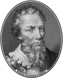
as well as to invade, the enemy; and when Pedro Alvarez Cabral sailed in 1500
in command of the second expedition to India his vessels were formidably armed
with artillery. By way of demonstrating his strength Cabral shortly after his
arrival captured a large Moorish vessel as it passed the roadstead and presented
her to the Zamorin. Suspecting the Moors of
obstructing him in procuring lading for his fleet, he attacked and captured a
Moorish vessel in the roadstead itself. In reprisal the Moors on shore
destroyed the Portuguese factory and massacred its inhabitants. Cabral seized
and destroyed ten large Moorish ships, and bombarded the town. He then sailed
for Cochin, burning two more ships of Calicut on the way. Cochin, the seat of a
Rajah hostile to the Zamorin, was also a port
frequented by the Moors, and a few of them resided there permanently. Cabral
was amicably received, completed his lading, and promised the Rajah to add
Calicut to his dominions, his design in this being to gain the Rajah’s
assistance in conquering Calicut for the Portuguese. Being now ready to return,
Cabral declined invitations from the Rajahs of Cananor and Quilon, and sailed for Europe. Having encountered a storm, he put into Cananor, where the Rajah promised free trade to the
Portuguese, and sent on board an envoy with presents for the Portuguese king.
Before his return Joao de Nueva had sailed from Lisbon for India, with four
ships and four hundred men. In view of the hostile attitude of the Zamorin, de Nueva made for Cananor,
where he learned that the Indian King was ready to attack him with forty ships.
Leaving his factors at Cananor, de Nueva sailed at
once to attack the enemy in their own waters, and inflicted on them a signal
defeat. Successful though the Portuguese had been, the tidings of this
continued hostility on the part of the Rajah who dominated the principal
emporium of India gave rise at home to grave misgivings. Some counseled the
abandonment of an enterprise to which the strength of a small European power
seemed unequal. Even if the resistance of Calicut were broken, what would be
the situation when Turkey and Egypt should combine with the Arabs to drive
Portugal from the precarious lodgment she had acquired? And if the mere
threshold of the Fast had proved so hard to win, how much harder would it be to
strike into the heart of the field, and attack the Muslim in the strong
positions of the Far East, with the countless millions of China at their back?
Against such
arguments the honor of a Christian nation, the lust of territorial
aggrandizement, and above all the greed of gold, prevailed in the end. Twenty
ships were dispatched, in three squadrons, under the general command of the
first adventurer, Vasco da Gama, and other commanders followed in rapid
succession. The original plan of campaign was still adhered to. Whatever the
cost, the Moors must be dislodged from Calicut, the resistance of the native
King broken, and the control of the trade transferred to the Portuguese, whose
King the Zamorin must acknowledge as his sovereign.
Beaten at every point in fair fight, the Zamorin maintained his ground by fraud and treachery. The stream of wealth still poured
into Portugal through Cochin and Cananor, immensely
augmented by the spoils of captured Moorish vessels, but the Zamorin still held his ground. In an interval during which
the Portuguese forces were weakened by the withdrawal of returning ships, he
attacked and destroyed Cochin. The Portuguese having retaken it, restored its
prince, and built a strong fort for themselves, the infuriated Rajah, having
roused such of his neighbors as were amenable to his appeal, seized a similar
opportunity and assailed Cochin with fifty thousand men. In a campaign of five
months he was defeated and slain by the Portuguese under Duarte Pacheco, who
earned the title of the Portuguese Achilles; but his successor maintained the
same attitude, and dispatched an embassy to the Sultan of Egypt, asking for aid
in resisting the invaders. The Sultan sent word to the Pope threatening to
destroy the holy places at Jerusalem if the Portuguese persisted in their
invasion of India. The only effect of this empty menace was to stimulate the
Portuguese King to renewed efforts on a larger scale. The crisis of the
struggle was approaching; and in view of this a more comprehensive scheme was
adopted. Abandoning the attempt to reduce the obstinate resistance of a single
prince, it was determined to attack the Muslim maritime system in all its
parts, and to establish a new emporium on the Malabar coast as the commercial
and naval centre of the new Portuguese eastern
empire. Already the Moorish traders in search of the produce of the Far East
had begun to avoid the Malabar coast, and to make their way from the Arabian
and African ports by a new route to Malacca. It was resolved to seize this key
of the Far East without delay, and to gain possession of the Moorish
settlements on the African coast, and the Arabian ports of Hormuz and Aden. By
exacting heavy duties at these places the whole trade would gradually be
diverted, and the Portuguese would ultimately control the Red Sea itself.
The chief African
settlements were seized with little difficulty by Francisco de Almeida; and the
rest of the programme was successfully carried out by
Alfonso de Albuquerque (1509-15). The excellent natural harbor of Goa had
already been chosen as the new seat of the Portuguese dominions. The town,
built by the Muslim fifty years previously, had lately fallen, together with
the adjacent country, under the sway of the powerful Adil Khan; and it was well known that here the Muslim enemy intended to concentrate
their forces with the view of driving the Portuguese from the Indian seas. A
Muslim pirate who foresaw the issue of the contest allied himself with the
Portuguese, on the terms that he should be appointed port-admiral of Goa, and farmer
of the large demesne lands which the conquest would annex to the Portuguese
Crown; and on March 4, 1510, Albuquerque entered Goa and received the keys of
the fortress. The dispossessed Hindoo inhabitants
welcomed the Portuguese as deliverers; and although Adil Khan forced his way again into the town, compelling the Portuguese to evacuate,
it was recaptured by Albuquerque (November 25), and strongly fortified. Many
Portuguese received grants of land, and married native women; the confiscated
estates of the Moorish mosques and Hindoo temples
were annexed to the great church of S. Catherina: a mint was set up, the new
coinage having on one side the cross of the Order of Christ, on the other
Manuel’s device of a sphere, lately adopted by him to signalize the vast
accession which his dominions had now received. Hindoos and Moors returned to the settlement, acknowledging the Portuguese supremacy;
and Goa thus became the most thriving port of the Malabar coast.
Albuquerque
followed up this success by sailing in person for Malacca, where he arrived in
June, 1511. A few Portuguese had already been allowed to settle there for the
purpose of trade. They had been treacherously attacked by the Moors, and their
property confiscated; and although a few effected their escape, several were
still held prisoners. Mohammad, the Sultan of Malacca, having refused
Albuquerque’s demand for their liberation and the restitution of their
property, Albuquerque assaulted and sacked the town, capturing hundreds of
guns, erected a fortress, set up a mint, and built a church dedicated to the
Virgin. The native princes of the adjoining mainland and islands hastened to
offer their friendship and urge the Portuguese commander to make his footing
secure. In this he completely succeeded, for although repeated attempts were
made to dislodge the Portuguese, the settlement was successfully defended, and
became, as was foreseen, a base from which all the Muslim settlements in the
Far East were gradually reduced to subjection.
The news of the
capture of Malacca was in due time communicated to the Court of Rome. A public
thanksgiving was appointed, marked by processions in which the Pope figured in
person. Later came an embassy from Portugal, headed by Tristan da Cunha, under
whom Albuquerque had seen his first service in the East. The presents of gold,
jewels, and oriental embroidery, an earnest of the future wealth to be drawn by
the Holy See from the East, were borne in triumphal procession. They were
followed by richly caparisoned Persian horses, leopards, a panther, and a
gigantic elephant, which knelt thrice before the Holy Father; and in reply to
an address Leo X delivered a Latin oration, in which he praised the maintenance
of peace by the Christian powers, and spoke hopefully of the union of their
forces against the Muslim. Meanwhile Albuquerque, having almost swept the
Turkish and Arab ships from the Indian sea, was preparing to carry the war into
their own waters.
Early in 1515 he
sailed from Goa with twenty vessels, and after an unsuccessful attack on Aden
entered the Red Sea. His successes had filled his mind with the wildest
expectations. By an alliance with the Christian sovereign of Abyssinia he
dreamed of establishing himself on the Upper Nile, cutting a canal through the
mountains separating it from the Red Sea, diverting the river, and thus turning
into a desert the most flourishing of the Muslim countries. Another project was
to land a force in the harbor of Yembo, plunder the
temple of Medina, and carry away Mohammad’s coffin, to be held until the holy
places of Jerusalem should be surrendered in exchange for it. A fiery cross,
seen over the African mist as he waited for a wind, was hailed as an omen of
success; but prudence and the affairs of Goa suggested his return, and after a very
limited reconnaissance of the Red Sea coasts he returned to India. The voyage
confirmed his belief in the capture and fortification of Aden as the necessary
means of effecting a junction with Abyssinia at the port of Massowah.
This once accomplished, Suez, Jiddah, and Mecca
itself would be practically at the invader’s mercy.
At another
important point Albuquerque strengthened the Portuguese position. Before
succeeding to the chief command he had set up a small Portuguese factory at the
ancient port of Hormuz, near the entrance of the Persian Gulf. From this the
Portuguese had advanced to obtaining control of the customs payable on Persian
exports to India. Albuquerque now obtained the surrender of the fort of Hormuz,
with the command of the entire import trade from India to Persia, as well as
through Mesopotamia to Aleppo, and Beyrut on the
Mediterranean. At the time of his death he was preparing an expedition for the
conquest of Aden, the only thing which seemed still undone in order to give
Portugal complete control of the eastern seas, being, in his own words, “the
closing of the gates of the Straits”. He died at Goa, habited as a commendador of the Order of Santiago. By his will he desired that his bones should be carried to Portugal.
This was strenuously opposed by the settlers of Goa, who believed their city to
be only safe so long as the bones of the great commander remained among them;
nor was it until fifty years later, when the Portuguese dominion seemed
absolutely safe from attack, that they were at length removed to Lisbon. During
these fifty years the main features of his scheme had been carried out.
Unmolested access to all the trading stations in the Far East was obtained, and
of many the Portuguese were in uncontrolled possession. In other places they
shared the trade with those whom they had hoped to expel. Albuquerque's scheme
for seizing and holding the Red Sea was abandoned: and the culmination of the
Portuguese successes in the East was followed by the rapid decline of their
power. We must now recur to the situation of other European powers at the time
of Dom Manuel’s succession to the throne in 1495.
Maritime
enterprise at Bristol. 1480-95
Not merely were
the Spaniards by this time actively preparing for the exploration and effective
occupation of their newly acquired transatlantic islands; but Englishmen, who
had so long been prosecuting westward discovery, and whose King, Henry VII, had
barely missed the prize which had fallen to the lot of Spain, now bestirred
themselves once more. Bristol was at this time one of the most considerable
ports in Europe; its merchants and seamen vied with those of Genoa and Venice,
and skilled navigators from those great ports here found ready employment.
Doubtless in 1495, or earlier, the news of Colombo’s success in a quest which
Bristol men had long made an interest of their own roused its merchants to
activity; and John Cabot, a citizen of Venice, though of Genoese extraction,
became the chosen instrument of their designs. Cabot’s three sons, Lewis,
Sebastian, and Sanctus, had apparently all been educated to his own calling;
and on March 5, 1496, Henry VII granted a petition preferred by the father and
sons, praying the sanction of the Crown to a voyage contemplated by them in
search of unknown countries, understood or believed to exist beyond the ocean
in northern latitudes. Having regard to the large commerce carried on between
Bristol and Iceland, and to the continuity of Icelandic tradition, embodied in
the Sagas, we entertain no doubt that the intention was to seek the New Land,
New Isle, or Vineland of the Northmen; and this conclusion is borne out by the
course actually taken when the voyage was begun. Pursuant to this petition,
still preserved in the Public Record Office, the Privy Seal was on the same day
affixed to the first charter authorizing its holders to hoist the English flag
on shores hitherto unknown to Christian people, and to acquire the sovereignty
of them for the English Crown. This charter, and the voyage made pursuant to
it, were put forward in a later generation, and are still sometimes regarded,
as the root of England’s title to her American possessions; and the date of the
letters patent (March 5, 1496) has not ineptly been styled the birthday of the
British Empire. It is stipulated that the grantees, who are authorized to enter
the Northern, Western, and Eastern seas, but not the Southern, shall after each
voyage return to the port of Bristol; that they shall then and there pay to the
Crown, in money or merchandise, one-fifth of their net profits: that they shall
be allowed to import their goods free of customs: and that no English subject
shall frequent the continents, islands, villages, towns, castles, and places
generally frequented by them without their licence.
While the Cabot grant disregards the Pope's supposed partition of the globe
between Portugal and Spain, it forbids, by implication, any intrusion into
those southern seas in which each of these powers had already acquired
territory by actual occupation. Colombo’s discoveries were as yet limited to
the chain of islands separating the Caribbean Sea from the Atlantic; the
Portuguese had not as yet set foot on American soil. The voyage of Cabot, which
had no practical results, and was soon well-nigh forgotten, will be briefly
noticed in our next chapter. Englishmen, eminently practical, saw in the
intelligence brought back by him no promise of a profitable commerce, or indeed
of commerce at all; nor did English colonial ideas take a definite shape until
nearly a century later.
Meanwhile the
Spanish monarchs, anxious to ascertain the extent of their transoceanic
possessions and to secure them from intrusion, licensed Vicente Yañez Pinzon, who had commanded a vessel under Colombo in
his first voyage, to prosecute the discovery of the supposed coast of Eastern
Asia. Pinzon was directed to avoid interference with the private rights
acquired by Colombo, and to visit only the coast to southward of the Orinoco,
the limit of Colombo’s explorations. Starting from the Cape Verde Islands on
November 14, 1499, and having on board Americo Vespucci, through whose narrative the voyage became well known, though the name
of the captain who conducted it was suppressed, Pinzon stood to the south-west
and struck the coast of Brazil near Cape St Augustin in the State of
Pernambuco. Sailing northwards along the coast, he rounded Cape San Roque, the
north-western promontory of South America, coasted along the north-eastern
shore of Brazil and the coasts of Guiana and Venezuela, passing the mouth of
the Amazon river, the rivers of Guiana, and the Orinoco, and reached the Gulf
of Paria, whence he made his way back to Europe,
bringing with him thirty Indian captives and a quantity of strange vegetable
products, including various dye-woods, from which the coast ultimately obtained
its permanent name of Brazil. When these new discoveries were laid down on the
chart, it became manifest that a considerable part of them were to the east of
the 370 leagues line, agreed on in 1494 as the boundary between the Spanish and
Portuguese areas of enterprise; and by a singular accident these very coasts
were reached in the last year of the fifteenth century by Pedro Alvarez Cabral,
the commander of the second Portuguese expedition to India and the Far East.
Like da Gama himself, Cabral proposed to cross from the Cape Verde Islands to
the Cape of Good Hope athwart the open sea, making, for the reason already
given in our description of da Gama’s voyage, an immense circuit to the
westward. In so doing he lost sight as might be anticipated, of one of his
ships; while seeking her he lost his course, and unexpectedly descried land. It
was the Brazilian coast, the mountain range called Pascal, in the State of
Bahia, to the south of the spot where Pinzon had landed three months
previously. Having discovered a safe harbor, named by him Porto Seguro, Cabral proceeded on his voyage to the Cape and
India. Thus was America discovered for the second time, and independently of
the enterprise of Colombo. The discovery was rapidly followed up. In May, 1501,
Manuel dispatched three vessels commissioned to explore from Porto Seguro southwards, as far as the coast within the
Portuguese line might extend. They returned in September, 1502, having
discovered it as far south as 32 degrees of south latitude. Adding this coast
to what had already been discovered by Colombo and others in the Caribbean Sea,
it will be seen that at the time of Colombo's death in 1506, and in the course
of fourteen years from his first voyage, about seven thousand miles of the
Atlantic coast of America had been revealed. As a mere matter of measurement,
this fell short of the length of coast-line which Portuguese enterprise had
added to, or rather, had accurately traced on, the map of Africa since the year
1426. But its geographical importance and general significance were far
greater, for it became more and more doubtful whether this immense coast could
possibly be the eastern shore of Asia. Colombo himself, in writing of the lands
reached by him, occasionally referred to them as constituting “Another world (orbis)” or “A new world”. The former expression had been
commonly employed in late Roman times to denote regions separated, or
apparently separated, by the ocean from the continent of Europe, such as the
British Islands were, and the Scandinavian peninsula was supposed to be. The
latter expression came into general use. It was employed by Vespucci in the
narrative of his voyages, which he circulated in manuscript with a view to his
own promotion in the maritime profession; a narrative which fell into the hands
of Martin Waldseemüller, a professor at St Die in
Lorraine, and was embodied in a brief outline of geography compiled by him and
printed in 1507. Half in jest, half seriously, Waldseemüller proposed to denominate the New World from the seaman whom he supposed to be its
discoverer, and gave it the name AMERICA.
By similar steps
proceeded the final stage of the great discovery, in which the New World was
revealed in something nearly approximating to its real extent, and its
discontinuity with Asia proved everywhere except in the northernmost parts of
the Pacific. From the Caribbean Sea Spanish explorers advanced northwards to
the Gulf of Mexico, circumnavigated Cuba, reached the peninsula of Florida and
the mouth of the Mississippi, proved the continuity of these northern shores
with the America of the South, and showed them to be probably continuous with
the New Land of the Northmen which had been revisited by Cabot, and
subsequently by the Portuguese navigator Cortereal.
This probability was strengthened by the voyage of the Florentine seaman
Giovanni da Verrazzano, commissioned for the purpose
by Francis I of France, in 1524, in circumstances to be mentioned presently.
Before this, not only had the Pacific been reached by crossing the continent in
more than one place, but Magalhaes had discovered and
passed the strait which bears his name. Juan Diaz de Solis in 1515 reached the
Plate River, where he and several companions were killed in a kidnapping raid
on the natives
Probably he
supposed himself to have reached the southern extremity of the continent.
Shortly afterwards the estuary was examined by a more famous captain, who
ascertained its real geographical character. Fernao de Magalhaes, a skillful Portuguese seaman who had
long been employed in the Portuguese trade to the Far East, having been refused
an increase of pay to which he considered himself fairly entitled, quitted the
service of Manuel, and sought to revenge himself by persuading Charles V that
the Spice Islands were within the hemisphere assigned to Spain by the treaty of
1494. He undertook to demonstrate this, and to conduct Spanish vessels thither
by a route round the southern cape of America; and on September 20, 1519, he
sailed from San Lucar for this purpose. The enormous
estuary of the Plate River had to be completely explored, in order to ascertain
that it was not in fact the passage of which he was in search; and more than a
year elapsed before this intrepid navigator found himself past the 50th
parallel of latitude, painfully coasting the barren and apparently interminable
coast of Patagonia. Nearly two months elapsed before he reached the Strait
which bears his name. On November 27, 1520, having occupied twenty days in
threading the Strait, he reached the Pacific; and fourteen months afterwards he
was slowly nearing the Ladrones, after accomplishing
the greatest feat of continuous seamanship the world has ever known. Magalhaes was fated not to complete his task. He fell by
the spear of a native at Zebu, one of the Philippine Islands, on April 27,
1521; and his vessel, the Victoria, was brought home on September 8,
1522, after making the first circumnavigation of the globe in a voyage which
occupied three years less fourteen days. The feat which Colombo proposed to
accomplish—a voyage to the Far Fast by a westward passage across the
Atlantic—was at length achieved, thirty years after its projector made the
first attempt to perform it, and twenty-four after he stumbled unexpectedly on
the vast continent which barred the way.
CHAPTER II
|
|
|
|
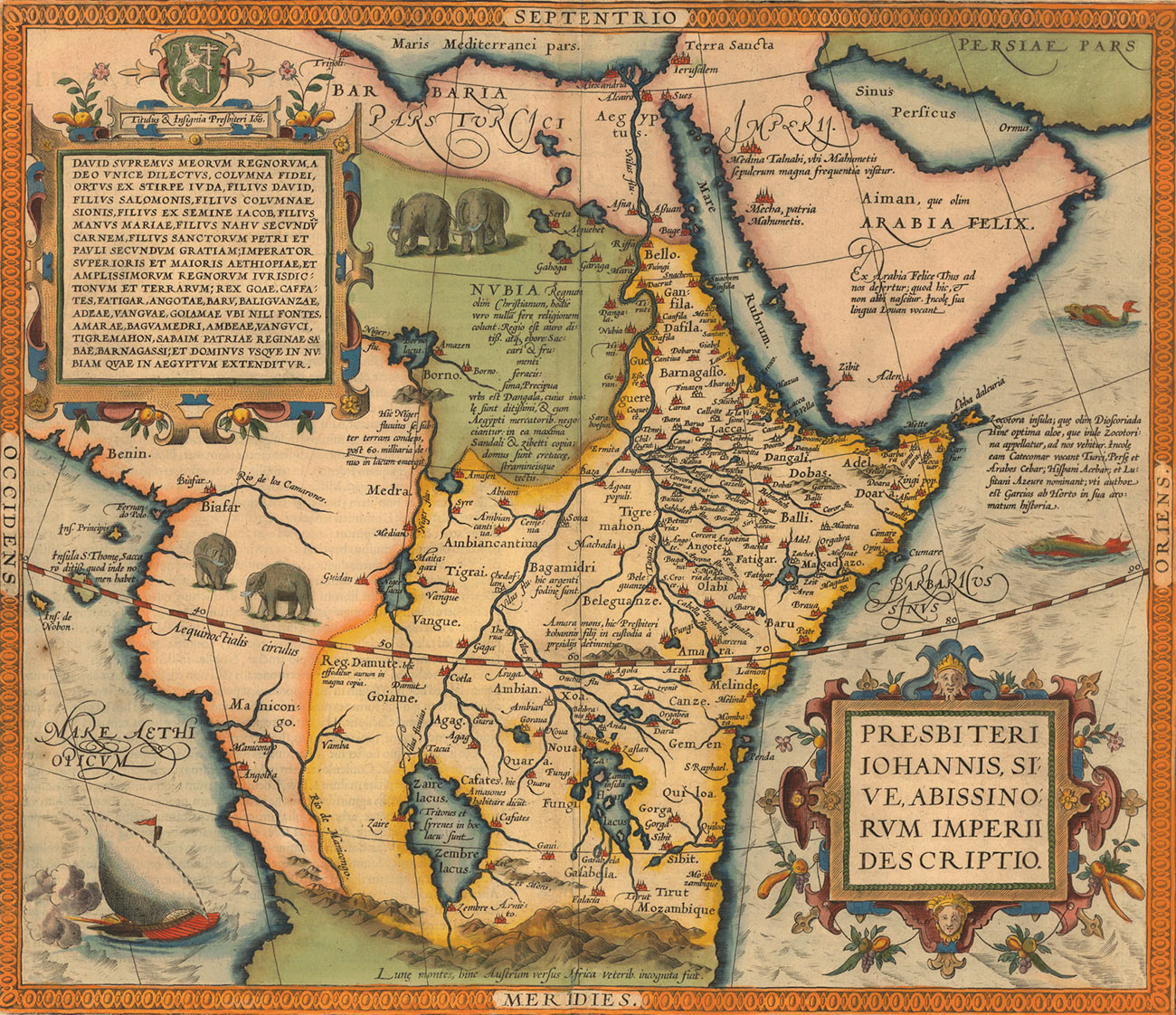
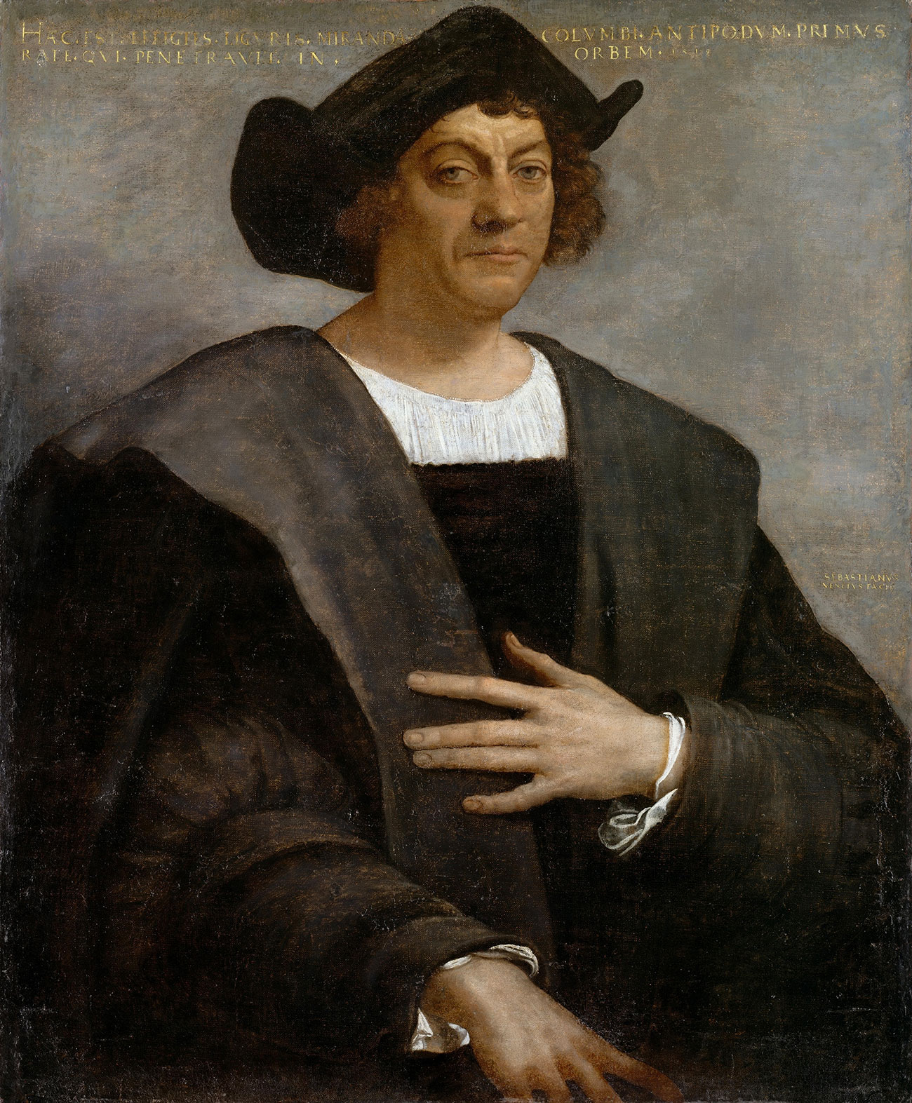
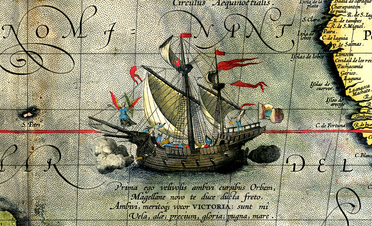

 |
 |
 |